
Menifee County topographic map
Interactive map
Click on the map to display elevation.
About this map
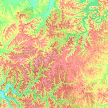
Name: Menifee County topographic map, elevation, terrain.
Location: Menifee County, Kentucky, VS (37.81840 -83.77553 38.05887 -83.43369)
Average elevation: 313 m
Minimum elevation: 199 m
Maximum elevation: 424 m
Other topographic maps
Click on a map to view its topography, its elevation and its terrain.
Hodgenville
VS > Kentucky > Hodgenville
Hodgenville, Larue County, Kentucky, VS
Average elevation: 229 m
Nationaal park Mammoth Cave
VS > Kentucky > Mammoth Cave
Nationaal park Mammoth Cave, Green River Ferry Road, Mammoth Cave, Edmonson County, Kentucky, VS
Average elevation: 215 m
Abraham Lincoln Birthplace National Historic Site
VS > Kentucky > Boundary Oak
Abraham Lincoln Birthplace National Historic Site, Boundary Oak, Larue County, Kentucky, VS
Average elevation: 238 m
The Meadow
VS > Kentucky > The Meadow
The Meadow, Jefferson County, Kentucky, 40242, VS
Average elevation: 200 m