
Allegany County topographic map
Interactive map
Click on the map to display elevation.
About this map
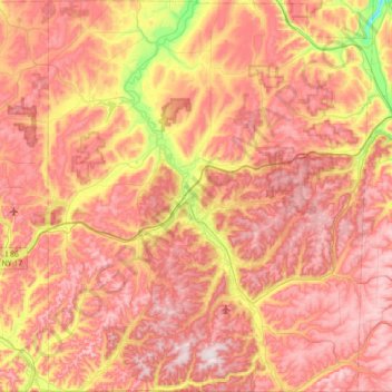
Name: Allegany County topographic map, elevation, terrain.
Location: Allegany County, New York, United States of America (41.99822 -78.30816 42.52002 -77.72294)
Average elevation: 561 m
Minimum elevation: 268 m
Maximum elevation: 779 m
Allegany County is in the southwestern part of New York State, along the Pennsylvania border. Allegany County does not lie along the Allegheny River, as its name would suggest. The highest point in the county is Alma Hill, with an elevation of 2,548 feet above sea level. This is the highest point in the state west of the Catskill Mountains. The highest point of Interstate 86 is located in the Town of West Almond with an elevation of 2,110 feet. This is also believed to be the highest point of any interstate in the New York. The County is unique from a watershed perspective as it is providing water to three major watersheds of North America: The eastern part near Alfred has Canacadea Creek that goes into the Canisteo River, Susquehanna River and eventually to Chesapeake Bay.
Other topographic maps
Click on a map to view its topography, its elevation and its terrain.
Battery Park City
United States of America > New York > Manhattan Community Board 1
Battery Park City, Manhattan Community Board 1, New York County, New York, United States of America
Average elevation: 5 m
Stony Point
United States of America > New York
Stony Point, Town of Stony Point, Rockland County, New York, 10980, United States of America
Average elevation: 71 m
North Brother Island
United States of America > New York > New York
North Brother Island, The Bronx, Bronx County, New York, United States of America
Average elevation: 4 m
Rockland County
United States of America > New York
Rockland County, New York, United States of America
Average elevation: 137 m
Queens
United States of America > New York
Queens, New York, United States of America
Average elevation: 11 m
Lighthouse Beach
United States of America > New York > Parma Town > Lighthouse Beach
Lighthouse Beach, Parma Town, Monroe, New York, United States of America
Average elevation: 76 m
Ontario County
United States of America > New York
Richmond Town, Ontario County, New York, 14471, United States of America
Average elevation: 399 m
Farmingville
United States of America > New York > Farmingville > Farmingville
Farmingville, Suffolk, New York, 11738, United States of America
Average elevation: 47 m
Rensselaer County
United States of America > New York
Rensselaer County, New York, United States of America
Average elevation: 239 m
Chenango County
United States of America > New York
Chenango County, New York, United States of America
Average elevation: 442 m