
Kembata Alaba Tembaro topographic map
Interactive map
Click on the map to display elevation.
About this map
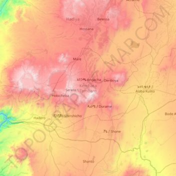
Name: Kembata Alaba Tembaro topographic map, elevation, terrain.
Location: Kembata Alaba Tembaro, Nations du Sud, Éthiopie (7.14577 37.35036 7.62491 38.43231)
Average elevation: 1,913 m
Minimum elevation: 815 m
Maximum elevation: 3,251 m
Other topographic maps
Click on a map to view its topography, its elevation and its terrain.
Emdibir
Éthiopie > Nations du Sud > Emdibir
Emdibir, Guraghe, Nations du Sud, Éthiopie
Average elevation: 2,084 m