
Yunlin County topographic map
Interactive map
Click on the map to display elevation.
About this map
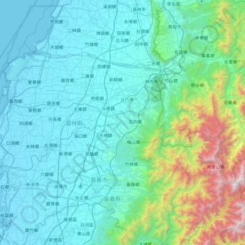
Name: Yunlin County topographic map, elevation, terrain.
Location: Yunlin County, Taiwan Province, Taiwan (23.41123 119.98249 23.86622 120.73615)
Average elevation: 391 m
Minimum elevation: -2 m
Maximum elevation: 2,850 m
Penglai Waterfall is located in Penny's Water Creek Valley on the east side of the Caoling settlement in Gukeng Township. It belongs to the Zhuoshui River Basin. The altitude of the waterfall is about 920 meters, and the drop is about 70 meters. It is listed as one of the ten scenic spots in Caoling.
Other topographic maps
Click on a map to view its topography, its elevation and its terrain.
Zhanghua City
Taiwan > Taiwan Province > Changhua County
Zhanghua City, Changhua County, Taiwan Province, Taiwan
Average elevation: 40 m
Taitung County
Taitung County, Taiwan Province, Taiwan
Average elevation: 325 m
Penglai
Taiwan > Taiwan Province > Nanzhuang > Penglai
Penglai, Penglai Village, Nanzhuang, Miaoli County, Taiwan Province, Taiwan
Average elevation: 638 m
Dabi Township
Taiwan > Taiwan Province > Dabi Township
Dabi Township, Yunlin County, Taiwan Province, 631, Taiwan
Average elevation: 25 m
Kanding
Taiwan > Taiwan Province > Kanding
Kanding, Pingtung County, Taiwan Province, 924, Taiwan
Average elevation: 9 m