
Germany topographic map
Interactive map
Click on the map to display elevation.
About this map
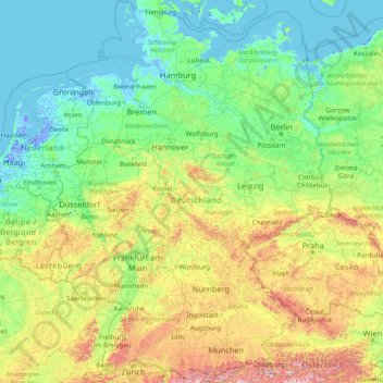
Name: Germany topographic map, elevation, terrain.
Location: Germany (47.27011 5.86632 55.09916 15.04193)
Average elevation: 237 m
Minimum elevation: -7 m
Maximum elevation: 2,744 m
Elevation ranges from the mountains of the Alps (highest point: the Zugspitze at 2,963 metres or 9,721 feet) in the south to the shores of the North Sea (Nordsee) in the northwest and the Baltic Sea (Ostsee) in the northeast. The forested uplands of central Germany and the lowlands of northern Germany (lowest point: in the municipality Neuendorf-Sachsenbande, Wilstermarsch at 3.54 metres or 11.6 feet below sea level) are traversed by such major rivers as the Rhine, Danube and Elbe. Significant natural resources include iron ore, coal, potash, timber, lignite, uranium, copper, natural gas, salt, and nickel.
Other topographic maps
Click on a map to view its topography, its elevation and its terrain.
India
India
Average elevation: 1,017 m
Sri Lanka
Sri Lanka
Average elevation: 50 m
Montreal
Canada > Quebec > Urban agglomeration of Montreal > Montreal
Montreal, Urban agglomeration of Montreal, Montreal (06), Quebec, H3B 1M7, Canada
Average elevation: 30 m
Hyderabad
India > Telangana > Bahadurpura mandal
Hyderabad, Bahadurpura mandal, Hyderabad District, Telangana, India
Average elevation: 549 m
Sirpur
India > Chhattisgarh > Mahasamund Tahsil
Sirpur, Mahasamund Tahsil, Mahasamund District, Chhattisgarh, India
Average elevation: 255 m
Thanjavur
India > Tamil Nadu > Thanjavur
Thanjavur, Thanjavur District, Tamil Nadu, 613001, India
Average elevation: 49 m
Sagwara
India > Rajasthan > Sagwara Tehsil
Sagwara, Sagwara Tehsil, Dungarpur District, Rajasthan, 314025, India
Average elevation: 177 m
Tacoma
United States > Washington > Pierce County
Tacoma, Pierce County, Washington, United States
Average elevation: 67 m
Pune
India > Maharashtra > Pune City > Pune
Pune, Pune City, Pune District, Maharashtra, 411001, India
Average elevation: 641 m
Bengaluru
India > Karnataka > Bangalore North
Bengaluru, Bangalore North, Bengaluru Urban, Karnataka, India
Average elevation: 886 m
Sabla
India > Rajasthan > Sabla Tehsil
Sabla, Sabla Tehsil, Dungarpur District, Rajasthan, 314022, India
Average elevation: 177 m
Surat
India > Gujarat > Katargam Taluka > Surat
Surat, Katargam Taluka, Surat, Gujarat, 395001, India
Average elevation: 11 m
Kanyakumari district
Kanyakumari district, Tamil Nadu, India
Average elevation: 226 m
Bhemai
India > Rajasthan > Galiakot Tehsil
Bhemai, Galiakot Tehsil, Dungarpur District, Rajasthan, India
Average elevation: 187 m
Bhatwari
Bhatwari, Uttarkashi District, Uttarakhand, India
Average elevation: 4,570 m
Musi River
Musi River, Hyderabad, Uppal mandal, Medchal–Malkajgiri, Telangana, 5000036, India
Average elevation: 490 m
Snohomish County
Snohomish County, Washington, United States
Average elevation: 649 m
Madurai
India > Tamil Nadu > Madurai
Madurai, Madurai South, Madurai district, Tamil Nadu, India
Average elevation: 138 m
Tanunda
Tanunda, The Barossa Council, South Australia, 5352, Australia
Average elevation: 276 m
Aspur
India > Rajasthan > Aspur Tehsil
Aspur, Aspur Tehsil, Dungarpur District, Rajasthan, 314021, India
Average elevation: 223 m
Gowari
India > Rajasthan > Sagwara Tehsil
Gowari, Sagwara Tehsil, Dungarpur District, Rajasthan, India
Average elevation: 178 m
Kariyana
India > Rajasthan > Sagwara Tehsil
Kariyana, Sagwara Tehsil, Dungarpur District, Rajasthan, 314032, India
Average elevation: 167 m
Jhonthri
India > Rajasthan > Jhonthtri Tehsil
Jhonthri, Jhonthtri Tehsil, Dungarpur District, Rajasthan, 314404, India
Average elevation: 284 m
Sirpur
India > Madhya Pradesh > Khalwa Tahsil
Sirpur, Khalwa Tahsil, Khandwa District, Madhya Pradesh, India
Average elevation: 313 m
Mandi
India > Himachal Pradesh > Mandi
Mandi, Mandi District, Himachal Pradesh, 175001, India
Average elevation: 1,273 m
Chennai
India > Tamil Nadu > Chennai
Chennai, Chennai District, Tamil Nadu, India
Average elevation: 8 m
Mangaluru
India > Karnataka > Mangaluru taluk
Mangaluru, Mangaluru taluk, Dakshina Kannada District, Karnataka, 575001, India
Average elevation: 25 m
Vadodara
India > Gujarat > Vadodara Taluka
Vadodara, Vadodara Taluka, Vadodara District, Gujarat, 390001, India
Average elevation: 36 m
Nepal
Nepal
Average elevation: 2,604 m
Springton
Springton, The Barossa Council, South Australia, 5235, Australia
Average elevation: 416 m
Borigama Chhota
India > Rajasthan > Sabla Tehsil
Borigama Chhota, Sabla Tehsil, Dungarpur District, Rajasthan, India
Average elevation: 169 m
Nadiya
India > Rajasthan > Galiakot Tehsil
Nadiya, Galiakot Tehsil, Dungarpur District, Rajasthan, India
Average elevation: 148 m
Bormali
India > Rajasthan > Simalwara Tehsil
Bormali, Simalwara Tehsil, Dungarpur District, Rajasthan, India
Average elevation: 227 m
Peeth
India > Rajasthan > Simalwara Tehsil
Peeth, Simalwara Tehsil, Dungarpur District, Rajasthan, 314406, India
Average elevation: 219 m
Silohi
India > Rajasthan > Galiakot Tehsil
Silohi, Galiakot Tehsil, Dungarpur District, Rajasthan, 314026, India
Average elevation: 140 m
Anaikatti
India > Tamil Nadu > Coimbatore North
Anaikatti, Mannarkad, Palakkad District, Kerala, 678741, India
Average elevation: 623 m
Kampur
India > Madhya Pradesh > Raisen Tahsil
Kampur, Raisen Tahsil, Raisen District, Madhya Pradesh, India
Average elevation: 462 m
Radisson
Canada > Saskatchewan > Division No. 16
Radisson, Division No. 16, Saskatchewan, S0K 3L0, Canada
Average elevation: 523 m