
Portugal topographic map
Interactive map
Click on the map to display elevation.
About this map
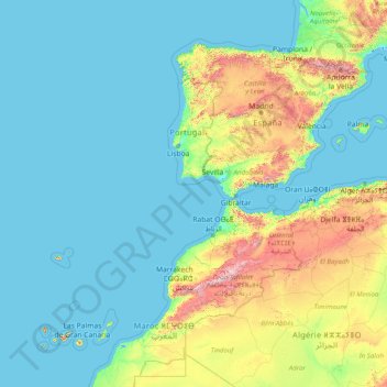
Name: Portugal topographic map, elevation, terrain.
Location: Portugal (29.82825 -31.55753 42.15431 -6.18916)
Average elevation: 268 m
Minimum elevation: -2 m
Maximum elevation: 3,622 m
Despite the calamity and huge death toll, Lisbon suffered no epidemics and within less than one year was already being rebuilt. The new city centre of Lisbon was designed to resist subsequent earthquakes. Architectural models were built for tests, and the effects of an earthquake were simulated by having troops march around the models. The buildings and large squares of the Pombaline Downtown still remain as one of Lisbon's tourist attractions. Carvalho e Melo also made an important contribution to the study of seismology by designing a detailed inquiry on the effects of the earthquake, the Parochial Memories of 1758, that was sent to every parish in the country; this wealth of information allows modern scientists to reconstruct the event with some degree of scientific precision while also giving current historians an immense amount of demographic, topographic and prosopographic information on the rest of the kingdom as well as information on its urban and rural areas.
Other topographic maps
Click on a map to view its topography, its elevation and its terrain.
India
India
Average elevation: 1,017 m
gehunlad
India > Uttarakhand > Chaubatta Khal
gehunlad, Chaubatta Khal, Pauri Garhwal District, Uttarakhand, India
Average elevation: 1,625 m
Hyderabad
India > Telangana > Bahadurpura mandal
Hyderabad, Bahadurpura mandal, Hyderabad District, Telangana, India
Average elevation: 549 m
Montreal
Canada > Quebec > Urban agglomeration of Montreal > Montreal
Montreal, Urban agglomeration of Montreal, Montreal (06), Quebec, H3B 1M7, Canada
Average elevation: 30 m
Tacoma
United States > Washington > Pierce County
Tacoma, Pierce County, Washington, United States
Average elevation: 67 m
Pune
India > Maharashtra > Pune City > Pune
Pune, Pune City, Pune District, Maharashtra, 411001, India
Average elevation: 641 m
Bengaluru
India > Karnataka > Bangalore North
Bengaluru, Bangalore North, Bengaluru Urban District, Karnataka, India
Average elevation: 881 m
Clappana
India > Kerala > Karunagappally
Clappana, Karunagappally, Kollam District, Kerala, 690525, India
Average elevation: 5 m
Dahej
India > Gujarat > Vagra Taluka
Dahej, Vagra Taluka, Bharuch District, Gujarat, 393125, India
Average elevation: 6 m
Kandy
Kandy, Kandy District, Central Province, 20000, Sri Lanka
Average elevation: 621 m
Siliguri
India > West Bengal > Siliguri Subdivsion
Siliguri, Siliguri Subdivsion, Darjeeling District, West Bengal, India
Average elevation: 121 m
Sri Lanka
Sri Lanka
Average elevation: 50 m
Warud
India > Maharashtra > Buldhana
Warud, Buldhana, Buldhana District, Maharashtra, India
Average elevation: 594 m
Badroud
Iran > Isfahan Province > Natanz County
Badroud, بخش امامزاده, Natanz County, Isfahan Province, 87661-37751, Iran
Average elevation: 994 m
Naula
India > Uttarakhand > Bhanoli
Naula, Bhanoli, Almora District, Uttarakhand, India
Average elevation: 1,562 m
Rajmachi Fort
India > Maharashtra > Mawal > Udhewadi
Rajmachi Fort, Udhewadi, Mawal, Pune District, Maharashtra, India
Average elevation: 501 m
Pura
Indonesia > East Nusa Tenggara > Alor
Pura, Alor, East Nusa Tenggara, Lesser Sunda Islands, Indonesia
Average elevation: 275 m
Malhargad Fort
India > Maharashtra > Purandhar
Malhargad Fort, Malhargad Walking Path, Purandhar, Pune District, Maharashtra, India
Average elevation: 822 m
Visapur Fort
India > Maharashtra > Mawal > Patan
Visapur Fort, Bhatrishi peak, Patan, Mawal, Pune District, Maharashtra, 410401, India
Average elevation: 818 m
Gladstone Regional
Gladstone Regional, Queensland, Australia
Average elevation: 116 m
Mount Maria
Mount Maria, Toowoomba Regional, Queensland, Australia
Average elevation: 382 m
Dadholi
India > Uttarakhand > Dwarahat
Dadholi, Dwarahat, Almora District, Uttarakhand, 263654, India
Average elevation: 1,449 m
Sinhagad Vikas Udyan
India > Maharashtra > Pune
Sinhagad Vikas Udyan, Vadgaon Budruk, Pune, Pune District, Maharashtra, 411051, India
Average elevation: 580 m
City of Medan
City of Medan, North Sumatra, Sumatra, Indonesia
Average elevation: 18 m
Shakarpur
India > Delhi > Gandhi Nagar Tehsil
Shakarpur, Gandhi Nagar Tehsil, East Delhi District, Delhi, India
Average elevation: 206 m
Mandi
India > Himachal Pradesh > Mandi
Mandi, Mandi District, Himachal Pradesh, 175001, India
Average elevation: 1,273 m
Kanyakumari district
Kanyakumari district, Tamil Nadu, India
Average elevation: 226 m
Haywood County
United States > North Carolina
Haywood County, North Carolina, United States
Average elevation: 1,044 m
Bhatwari
Bhatwari, Uttarkashi District, Uttarakhand, India
Average elevation: 4,570 m
Musi River
Musi River, Hyderabad, Uppal mandal, Medchal–Malkajgiri, Telangana, 5000036, India
Average elevation: 490 m
Panvel
India > Maharashtra > Panvel > Panvel
Panvel, Raigad, Maharashtra, 410206, India
Average elevation: 75 m
saraikhet
India > Uttarakhand > Dhoomakot
saraikhet, Dhoomakot, Pauri Garhwal District, Uttarakhand, India
Average elevation: 1,861 m
Dudori
India > Uttarakhand > Syalde > Kaljipa
Dudori, Kaljipa, Syalde, Almora District, Uttarakhand, 263665, India
Average elevation: 1,564 m
Bourne
United States > Massachusetts > Barnstable County
Bourne, Barnstable County, Massachusetts, United States
Average elevation: 20 m
Dexter Canyon
United States > California > Santa Clara County
Dexter Canyon, Santa Clara County, California, United States
Average elevation: 529 m
Broomehill Village
Broomehill Village, Shire Of Broomehill-Tambellup, Western Australia, Australia
Average elevation: 325 m
Vairavanpatti
India > Tamil Nadu > Thiruppathur
Vairavanpatti, Thiruppathur, Sivagangai District, Tamil Nadu, 630207, India
Average elevation: 103 m
Chennai
India > Tamil Nadu > Chennai
Chennai, Chennai District, Tamil Nadu, India
Average elevation: 8 m