
Nathdwara topographic map
Interactive map
Click on the map to display elevation.
About this map
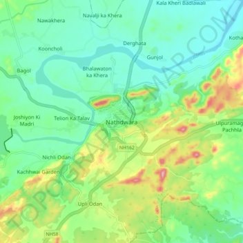
Name: Nathdwara topographic map, elevation, terrain.
Average elevation: 590 m
Minimum elevation: 538 m
Maximum elevation: 713 m
Nathdwara is located at 24°56′N 73°49′E / 24.93°N 73.82°E / 24.93; 73.82. It has an average elevation of 584 metres (1919 ft). Located just 48 km north-east of Udaipur in Rajasthan, this town is easily reached by air, road or nearest rail-head.