
Madanapalle topographic map
Interactive map
Click on the map to display elevation.
About this map
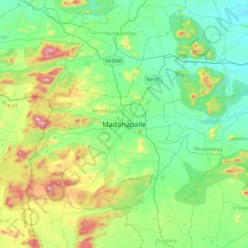
Name: Madanapalle topographic map, elevation, terrain.
Location: Madanapalle, Annamayya District, Andhra Pradesh, 517300, India (13.39580 78.34087 13.71580 78.66087)
Average elevation: 766 m
Minimum elevation: 555 m
Maximum elevation: 1,355 m
It is located at an average elevation of 695 m (2,280 ft) above mean sea level.
Other topographic maps
Click on a map to view its topography, its elevation and its terrain.
Pangunuruvaripalle
India > Andhra Pradesh > Madanapalle
Pangunuruvaripalle, Madanapalle, Annamayya, Andhra Pradesh, 517325, India
Average elevation: 704 m