
Thank you for supporting this site ❤️
Make a donation
Make a donation
Vrindavan topographic map
Click on the map to display elevation.
Thank you for supporting this site ❤️
Make a donation
Make a donation
Vrindavan
Vrindavan is situated on the west bank of the Yamuna River, about 15 kilometres north of Mathura. "Maps, Weather, and Airports for Vrindavan, India". www.fallingrain.com. Retrieved 6 December 2019.</ref> It has an average elevation of 170 metres (557 feet).
Thank you for supporting this site ❤️
Make a donation
Make a donation
About this map
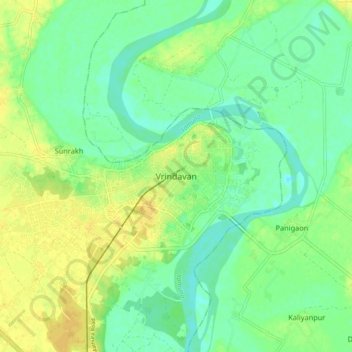
Name: Vrindavan topographic map, elevation, terrain.
Location: Vrindavan, Mathura, Uttar Pradesh, 281121, India (27.53537 77.65380 27.61537 77.73380)
Average elevation: 172 m
Minimum elevation: 161 m
Maximum elevation: 184 m
Thank you for supporting this site ❤️
Make a donation
Make a donation
Other topographic maps
Click on a map to view its topography, its elevation and its terrain.