
's-Hertogenbosch topographic map
Interactive map
Click on the map to display elevation.
About this map
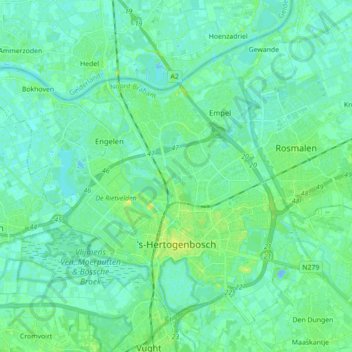
Name: 's-Hertogenbosch topographic map, elevation, terrain.
Location: 's-Hertogenbosch, North Brabant, Netherlands (51.66400 5.20649 51.75573 5.38221)
Average elevation: 4 m
Minimum elevation: -10 m
Maximum elevation: 14 m
Other topographic maps
Click on a map to view its topography, its elevation and its terrain.
Hoogerheide
Hoogerheide, Woensdrecht, North Brabant, Netherlands
Average elevation: 12 m
Eindhoven
Netherlands > North Brabant > Eindhoven
Eindhoven, North Brabant, Netherlands, 5611EB, Netherlands
Average elevation: 21 m
Mill
Netherlands > North Brabant > Mill en Sint Hubert
Mill, Mill en Sint Hubert, North Brabant, Netherlands
Average elevation: 14 m
Eindhoven
Netherlands > North Brabant > Eindhoven
Eindhoven, North Brabant, Netherlands
Average elevation: 20 m