
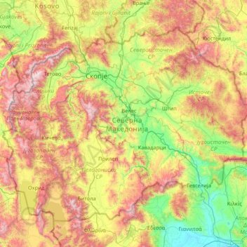
North Macedonia topographic map
Interactive map
Click on the map to display elevation.
About this map
Name: North Macedonia topographic map, elevation, terrain.
Location: North Macedonia (40.85366 20.45290 42.37390 23.03405)
Average elevation: 799 m
Minimum elevation: 0 m
Maximum elevation: 2,673 m
Four different seasons are found in the country with warm and dry summers and moderately cold and snowy winters. The range of temperatures recorded throughout the year ranges from −20 °C (−4 °F) in winter, to 40 °C (104 °F) in summer. Low winter temperatures are influenced by winds from the north while heat seasons during summer arise due to the subtropical pressure of the Aegean Sea and climate influences from the Middle East, with the latter causing dry periods. There are three main climatic zones in the country: mildly continental in the north, temperate Mediterranean in the south and mountainous in the zones with high altitude. Along the valleys of the Vardar and Strumica rivers, in the regions of Gevgelija, Valandovo, Dojran, Strumica, and Radoviš, the climate is temperate Mediterranean. The warmest regions are Demir Kapija and Gevgelija, where the temperature in July and August frequently exceeds 40 °C (104 °F).
Other topographic maps
Click on a map to view its topography, its elevation and its terrain.
Sri Lanka
Sri Lanka
Average elevation: 50 m
Hyderabad
India > Telangana > Bahadurpura mandal
Hyderabad, Bahadurpura mandal, Hyderabad District, Telangana, India
Average elevation: 549 m
Montreal
Canada > Quebec > Urban agglomeration of Montreal > Montreal
Montreal, Urban agglomeration of Montreal, Montreal (06), Quebec, H3B 1M7, Canada
Average elevation: 30 m
Tacoma
United States > Washington > Pierce County
Tacoma, Pierce County, Washington, United States
Average elevation: 67 m
India
India
Average elevation: 1,017 m
Navi Mumbai
India > Maharashtra > Thane > Navi Mumbai
Navi Mumbai, Mumbai Metropolitan Region, Thane, Maharashtra, 400706, India
Average elevation: 30 m
Bengaluru
India > Karnataka > Bangalore North
Bengaluru, Bangalore North, Bengaluru Urban District, Karnataka, India
Average elevation: 881 m
Kandy
Kandy, Kandy District, Central Province, 20000, Sri Lanka
Average elevation: 621 m
Chasiv Yar
Chasiv Yar, Chasiv Yar urban hromada, Bakhmut Raion, Donetsk Oblast, 84551-84556, Ukraine
Average elevation: 213 m
Udaipur
India > Rajasthan > Girwa Tehsil
Udaipur, Girwa Tehsil, Udaipur District, Rajasthan, 313001, India
Average elevation: 656 m
Karavas
Karavas, Lapta-Alsancak-Çamlıbel Belediyesi, Girne (Kyrenia) District, Northern Cyprus, Cyprus
Average elevation: 239 m
Montagnole
France > Auvergne-Rhône-Alpes > Savoy
Montagnole, Chambéry, Savoy, Auvergne-Rhône-Alpes, Metropolitan France, 73000, France
Average elevation: 685 m
Musi River
Musi River, Hyderabad, Uppal mandal, Medchal–Malkajgiri, Telangana, 5000036, India
Average elevation: 490 m
Gopasandra
India > Karnataka > Mulubagilu taluk
Gopasandra, Mulubagilu taluk, Kolar District, Karnataka, India
Average elevation: 804 m
Hubli
India > Karnataka > Hubballi Urban Taluku
Hubli, Hubballi Urban Taluku, Dharwad District, Karnataka, 580020, India
Average elevation: 626 m
Dehradun
India > Uttarakhand > Dehradun
Dehradun, Dehradun District, Uttarakhand, 248001, India
Average elevation: 904 m
Vadodara
India > Gujarat > Vadodara Taluka
Vadodara, Vadodara Taluka, Vadodara District, Gujarat, 390001, India
Average elevation: 36 m
Kanyakumari district
Kanyakumari district, Tamil Nadu, India
Average elevation: 226 m
Snohomish County
Snohomish County, Washington, United States
Average elevation: 649 m
Itu
Brazil > São Paulo > Região Metropolitana de Sorocaba
Itu, Região Imediata de Sorocaba, Região Metropolitana de Sorocaba, Região Geográfica Intermediária de Sorocaba, São Paulo, Southeast Region, Brazil
Average elevation: 630 m
Pune
India > Maharashtra > Pune City > Pune
Pune, Pune City, Pune District, Maharashtra, 411001, India
Average elevation: 641 m
Kaluvoya
Kaluvoya, Sri Potti Sriramulu Nellore, Andhra Pradesh, India
Average elevation: 133 m
Pipliya
India > Madhya Pradesh > Khandwa Tahsil
Pipliya, Khandwa Tahsil, Khandwa District, Madhya Pradesh, India
Average elevation: 360 m
Delhi
India > Delhi > Kotwali Tehsil
Delhi, Kotwali Tehsil, Central Delhi, Delhi, 110006, India
Average elevation: 216 m
Pallam
India > Andhra Pradesh > Yerpedu
Pallam, Yerpedu, Tirupati, Andhra Pradesh, 517620, India
Average elevation: 81 m
Panvel
India > Maharashtra > Panvel > Panvel
Panvel, Raigad, Maharashtra, 410206, India
Average elevation: 75 m
Chennai
India > Tamil Nadu > Chennai
Chennai, Chennai District, Tamil Nadu, India
Average elevation: 8 m
Tathawade
India > Maharashtra > Mulshi
Tathawade, Mulshi, Pune, Maharashtra, 410005, India
Average elevation: 577 m
Jewar
India > Madhya Pradesh > Lidhaura Tahsil
Jewar, Lidhaura Tahsil, Tikamgarh District, Madhya Pradesh, 284205, India
Average elevation: 232 m
Gunjur Palya
India > Karnataka > Bangalore East
Gunjur Palya, Bangalore East, Bengaluru Urban, Karnataka, 560087, India
Average elevation: 883 m
Katara
India > Madhya Pradesh > Kolar Tahsil
Katara, Kolar Tahsil, Bhopal District, Madhya Pradesh, India
Average elevation: 462 m
Chempakapara
India > Kerala > Udumbanchola > Chempakappara > Kochukamakshy
Chempakapara, Kochukamakshy, Chempakappara, Udumbanchola, Idukki District, Kerala, India
Average elevation: 811 m
Kuvalettam
Kuvalettam, Peerumade, Idukki District, Kerala, 685503, India
Average elevation: 979 m
Lúcumo Hills
Peru > Lima > Lima Metropolitan Area
Lúcumo Hills, Lima Metropolitan Area, Lima, 15088, Peru
Average elevation: 283 m
Tijuana
Mexico > Baja California > Municipio de Tijuana
Tijuana, Municipio de Tijuana, Baja California, 22320, Mexico
Average elevation: 141 m
Top view desert stp
Egypt > Matruh > Siwa Oasis
Top view desert stp, Street 17, Siwa Oasis, Matruh, Egypt
Average elevation: -13 m