
Denmark topographic map
Interactive map
Click on the map to display elevation.
About this map
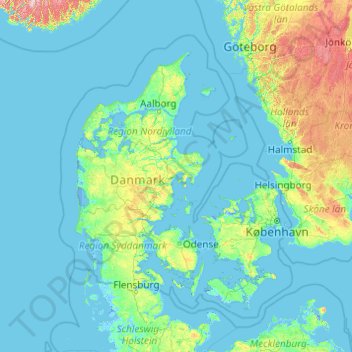
Name: Denmark topographic map, elevation, terrain.
Location: Denmark (54.45167 7.71533 57.95243 15.55306)
Average elevation: 30 m
Minimum elevation: -5 m
Maximum elevation: 596 m
Spanning a total area of 42,943 km2 (16,580 sq mi), it consists of the peninsula of Jutland and an archipelago of 443 named islands, of which the largest are Zealand, Funen and the North Jutlandic Island. Denmark's geography is characterised by flat, arable land, sandy coasts, low elevation, and a temperate climate. As of 2022, it had a population of 5.928 million (1 October 2022), of which 800,000 live in the capital and largest city, Copenhagen. Denmark exercises hegemonic influence in the Danish Realm, devolving powers to handle internal affairs. Home rule was established in the Faroe Islands in 1948 and in Greenland in 1979; the latter obtained further autonomy in 2009.
Other topographic maps
Click on a map to view its topography, its elevation and its terrain.
India
India
Average elevation: 1,017 m
Montreal
Canada > Quebec > Urban agglomeration of Montreal > Montreal
Montreal, Urban agglomeration of Montreal, Montreal (06), Quebec, H3B 1M7, Canada
Average elevation: 30 m
Tacoma
United States > Washington > Pierce County
Tacoma, Pierce County, Washington, United States
Average elevation: 67 m
Hyderabad
India > Telangana > Bahadurpura mandal
Hyderabad, Bahadurpura mandal, Hyderabad District, Telangana, India
Average elevation: 549 m
Sri Lanka
Sri Lanka
Average elevation: 50 m
Bengaluru
India > Karnataka > Bangalore North
Bengaluru, Bangalore North, Bengaluru Urban District, Karnataka, India
Average elevation: 881 m
Kandy
Kandy, Kandy District, Central Province, 20000, Sri Lanka
Average elevation: 621 m
Pune
India > Maharashtra > Pune City > Pune
Pune, Pune City, Pune District, Maharashtra, 411001, India
Average elevation: 641 m
saraikhet
India > Uttarakhand > Dhoomakot
saraikhet, Dhoomakot, Pauri Garhwal District, Uttarakhand, India
Average elevation: 1,861 m
Bhatwari
Bhatwari, Uttarkashi District, Uttarakhand, India
Average elevation: 4,570 m
Chennai
India > Tamil Nadu > Chennai
Chennai, Chennai District, Tamil Nadu, India
Average elevation: 8 m
Dudori
India > Uttarakhand > Syalde > Kaljipa
Dudori, Kaljipa, Syalde, Almora District, Uttarakhand, 263665, India
Average elevation: 1,564 m
Vairavanpatti
India > Tamil Nadu > Thiruppathur
Vairavanpatti, Thiruppathur, Sivagangai District, Tamil Nadu, 630207, India
Average elevation: 103 m
Surat
India > Gujarat > Katargam Taluka > Surat
Surat, Katargam Taluka, Surat, Gujarat, 395001, India
Average elevation: 11 m
Gladstone Regional
Gladstone Regional, Queensland, Australia
Average elevation: 116 m
Mount Maria
Mount Maria, Toowoomba Regional, Queensland, Australia
Average elevation: 382 m
Dadholi
India > Uttarakhand > Dwarahat
Dadholi, Dwarahat, Almora District, Uttarakhand, 263654, India
Average elevation: 1,449 m
Sinhagad Vikas Udyan
India > Maharashtra > Pune
Sinhagad Vikas Udyan, Vadgaon Budruk, Pune, Pune District, Maharashtra, 411051, India
Average elevation: 580 m
City of Medan
City of Medan, North Sumatra, Sumatra, Indonesia
Average elevation: 18 m
Shakarpur
India > Delhi > Gandhi Nagar Tehsil
Shakarpur, Gandhi Nagar Tehsil, East Delhi District, Delhi, India
Average elevation: 206 m
Clappana
India > Kerala > Karunagappally
Clappana, Karunagappally, Kollam District, Kerala, 690525, India
Average elevation: 5 m
Bourne
United States > Massachusetts > Barnstable County
Bourne, Barnstable County, Massachusetts, United States
Average elevation: 20 m
Dexter Canyon
United States > California > Santa Clara County
Dexter Canyon, Santa Clara County, California, United States
Average elevation: 529 m
Broomehill Village
Broomehill Village, Shire Of Broomehill-Tambellup, Western Australia, Australia
Average elevation: 325 m
Haywood County
United States > North Carolina
Haywood County, North Carolina, United States
Average elevation: 1,044 m
Nepal
Nepal
Average elevation: 2,604 m
Kariyana
India > Rajasthan > Sagwara Tehsil
Kariyana, Sagwara Tehsil, Dungarpur District, Rajasthan, 314032, India
Average elevation: 167 m
Panvel
India > Maharashtra > Panvel > Panvel
Panvel, Raigad, Maharashtra, 410206, India
Average elevation: 75 m
Thiruvananthapuram
India > Kerala > Thiruvananthapuram
Thiruvananthapuram, Thiruvananthapuram District, Kerala, 695001, India
Average elevation: 33 m
Vadodara
India > Gujarat > Vadodara Taluka
Vadodara, Vadodara Taluka, Vadodara District, Gujarat, 390001, India
Average elevation: 36 m
Trenčín
Slovakia > Region of Trenčín > District of Trenčín
Trenčín, District of Trenčín, Region of Trenčín, Western Slovakia, Slovakia
Average elevation: 307 m
Ilam
Nepal > Koshi Province > Ilam
Ilam, Illam, Ilam, Koshi Province, 57300, Nepal
Average elevation: 919 m
Bajwad
India > Uttarakhand > Garud
Bajwad, Garud, Bageshwar District, Uttarakhand, India
Average elevation: 1,755 m
Gilroy Hot Springs
United States > California > Santa Clara County
Gilroy Hot Springs, Santa Clara County, California, United States
Average elevation: 525 m
Udaipur
India > Rajasthan > Girwa Tehsil
Udaipur, Girwa Tehsil, Udaipur District, Rajasthan, 313001, India
Average elevation: 656 m
Mangaluru
India > Karnataka > Mangaluru taluk
Mangaluru, Mangaluru taluk, Dakshina Kannada District, Karnataka, 575001, India
Average elevation: 25 m
Siliguri
India > West Bengal > Siliguri Subdivsion
Siliguri, Siliguri Subdivsion, Darjeeling District, West Bengal, India
Average elevation: 121 m
Dehradun
India > Uttarakhand > Dehradun
Dehradun, Dehradun District, Uttarakhand, 248001, India
Average elevation: 904 m