
Chittorgarh topographic map
Interactive map
Click on the map to display elevation.
About this map
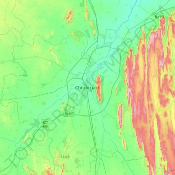
Name: Chittorgarh topographic map, elevation, terrain.
Average elevation: 442 m
Minimum elevation: 371 m
Maximum elevation: 617 m
Other topographic maps
Click on a map to view its topography, its elevation and its terrain.
Chanderiya
India > Rajasthan > Chittaurgarh Tehsil
Chanderiya, Chittaurgarh Tehsil, Chittorgarh District, Rajasthan, 312021, India
Average elevation: 404 m