
Make a donation
Gorakhpur topographic map
Click on the map to display elevation.
Make a donation
About this map
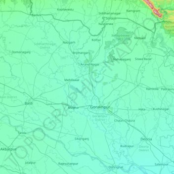
Name: Gorakhpur topographic map, elevation, terrain.
Location: Gorakhpur, Gorakhpur District, Uttar Pradesh, 273165, India (26.21667 82.55000 27.61667 83.95000)
Average elevation: 90 m
Minimum elevation: 58 m
Maximum elevation: 807 m
Make a donation
Other topographic maps
Click on a map to view its topography, its elevation and its terrain.
Make a donation
Make a donation
Make a donation
Make a donation
Raebareli
Raebareli district is located in the southern part of Awadh, at the southern end of Lucknow Division. It is compact in shape — no part of the district is especially far from the city of Raebareli. In general, the terrain is flat or gently undulating, and the soil is especially fertile and well-suited to…
Average elevation: 111 m
Make a donation
Saharanpur
Saharanpur is located at 29°58′N 77°33′E / 29.97°N 77.55°E / 29.97; 77.55, about 130 kilometres (81 mi) south-southeast from Chandigarh and 170 kilometres (110 mi) north-northeast from Delhi and 61 Km. South of Dehradun and about 70 Km. South East from the town of Paonta Sahib, Himachal…
Average elevation: 307 m
Banda
The hills of the district consist of the part of the Vindhyan plateau which lies in the extreme southern portion of the tahsils Mau and Karwi (now known as the district Chitrakut). The northern flank of the Vindhyas known as Vindhyachal range, starts near the Yamuna in the extreme east of tahsil Mau. It…
Average elevation: 137 m
Make a donation
Mahakali River
India > Uttar Pradesh > Lakhimpur
The Sharda River is the downstream of Kāli River (or Mahakali River) that originates in the northern Uttarakhand state of India in the Great Himalayas on the eastern slopes of Nanda Devi massif, at an elevation of 3,600 m (11,800 ft) in the Pithoragarh district. It then flows on the Nepal and India border.…
Average elevation: 135 m
Make a donation
Make a donation
Make a donation
Make a donation
Make a donation
Make a donation
Make a donation
Make a donation
Make a donation
Make a donation
Barabanki
Barabanki district is for the most part flat agricultural lands studded with groves. The most elevated point is about 130 metres (430 ft) above sea level, and there are few points of view from which any expanse of the countryside can be surveyed. In the north, the topography is broken by a 6.1-metre (20 ft)…
Average elevation: 113 m
Make a donation
Kanpur
Situated in the flat Indo-Gangetic Plains, Kanpur has an average elevation of 318 m above sea level. The Ganga flows by the city and several ghats are located on its banks, notably the Sati Chaura Ghat and Sarsaiya Ghat. The Brahmavart Ghat located at Bithoor (25 km northwards) is another ghat of religious…
Average elevation: 124 m
Make a donation
Make a donation
Make a donation
Make a donation
Make a donation
Dudhwa National Park
India > Uttar Pradesh > Palia
Dudhwa National Park is located in Lakhimpur Kheri district of Uttar Pradesh. The area of the park falls within the Upper Gangetic plains and is a vast alluvial plain ranging in elevation from 150 m (490 ft) in the farthest southeast to 182 m (597 ft) in the north.
Average elevation: 163 m
Make a donation
Make a donation
Make a donation