
Thank you for supporting this site ❤️
Make a donation
Make a donation
Kakinada topographic map
Click on the map to display elevation.
Thank you for supporting this site ❤️
Make a donation
Make a donation
Kakinada
Kakinada is located at 16°56′N 82°13′E / 16.93°N 82.22°E / 16.93; 82.22, with the 82-degrees east longitude passing through the city. The city has an average elevation of 2 meters (6.6 feet), and several areas lie below sea level.
Thank you for supporting this site ❤️
Make a donation
Make a donation
About this map
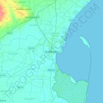
Name: Kakinada topographic map, elevation, terrain.
Average elevation: 7 m
Minimum elevation: -2 m
Maximum elevation: 99 m
Thank you for supporting this site ❤️
Make a donation
Make a donation