
Argentina topographic map
Interactive map
Click on the map to display elevation.
About this map
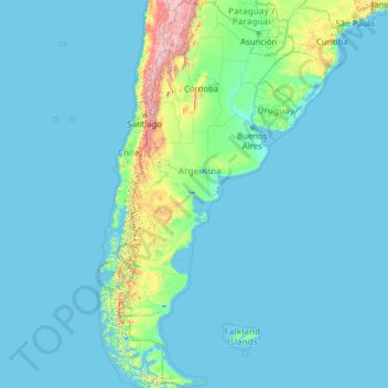
Name: Argentina topographic map, elevation, terrain.
Location: Argentina (-55.19257 -73.56054 -21.78086 -53.63745)
Average elevation: 198 m
Minimum elevation: -2 m
Maximum elevation: 6,482 m
In general, Argentina has four main climate types: warm, moderate, arid, and cold, all determined by the expanse across latitude, range in altitude, and relief features. Although the most populated areas are generally temperate, Argentina has an exceptional amount of climate diversity, ranging from subtropical in the north to polar in the far south. Consequently, there is a wide variety of biomes in the country, including subtropical rain forests, semi-arid and arid regions, temperate plains in the Pampas, and cold subantarctic in the south. The average annual precipitation ranges from 150 millimetres (6 in) in the driest parts of Patagonia to over 2,000 millimetres (79 in) in the westernmost parts of Patagonia and the northeastern parts of the country. Mean annual temperatures range from 5 °C (41 °F) in the far south to 25 °C (77 °F) in the north.
Other topographic maps
Click on a map to view its topography, its elevation and its terrain.
Hyderabad
India > Telangana > Bahadurpura mandal
Hyderabad, Bahadurpura mandal, Hyderabad District, Telangana, India
Average elevation: 549 m
India
India
Average elevation: 1,017 m
Sri Lanka
Sri Lanka
Average elevation: 50 m
Navi Mumbai
India > Maharashtra > Thane > Navi Mumbai
Navi Mumbai, Mumbai Metropolitan Region, Thane, Maharashtra, 400706, India
Average elevation: 30 m
Karchiganuru
India > Karnataka > Siruguppa taluku
Karchiganuru, Siruguppa taluku, Ballari District, Karnataka, India
Average elevation: 366 m
Montreal
Canada > Quebec > Urban agglomeration of Montreal > Montreal
Montreal, Urban agglomeration of Montreal, Montreal (06), Quebec, H3B 1M7, Canada
Average elevation: 30 m
Pune
India > Maharashtra > Pune City > Pune
Pune, Pune City, Pune District, Maharashtra, 411001, India
Average elevation: 641 m
Colombo
Colombo, Colombo District, Western Province, Sri Lanka
Average elevation: 5 m
Tacoma
United States > Washington > Pierce County
Tacoma, Pierce County, Washington, United States
Average elevation: 67 m
Kandy
Kandy, Kandy District, Central Province, 20000, Sri Lanka
Average elevation: 621 m
Bengaluru
India > Karnataka > Bangalore North
Bengaluru, Bangalore North, Bengaluru Urban District, Karnataka, India
Average elevation: 881 m
Kurunegala
Sri Lanka > North Western Province
Kurunegala, Kurunegala District, North Western Province, 60000, Sri Lanka
Average elevation: 146 m
Musi River
Musi River, Hyderabad, Uppal mandal, Medchal–Malkajgiri, Telangana, 5000036, India
Average elevation: 490 m
Dehradun
India > Uttarakhand > Dehradun
Dehradun, Dehradun District, Uttarakhand, 248001, India
Average elevation: 904 m
Sulusaray Beldesi
Sulusaray Beldesi, Nevşehir Merkez, Nevşehir, Central Anatolia Region, Turkey
Average elevation: 1,008 m
Mangaluru
India > Karnataka > Mangaluru taluk
Mangaluru, Mangaluru taluk, Dakshina Kannada District, Karnataka, 575001, India
Average elevation: 25 m
Bhopal
India > Madhya Pradesh > Huzur Tahsil
Bhopal, Huzur Tahsil, Bhopal District, Madhya Pradesh, 462001, India
Average elevation: 498 m
Calvary Mount
Calvary Mount, Idukki, Idukki District, Kerala, 685512, India
Average elevation: 944 m
Vadodara
India > Gujarat > Vadodara Taluka
Vadodara, Vadodara Taluka, Vadodara District, Gujarat, 390001, India
Average elevation: 36 m
South Korea
South Korea
Average elevation: 79 m
Pedurungan
Indonesia > Central Java > Semarang
Pedurungan, Semarang, Central Java, Java, Indonesia
Average elevation: 19 m
Dahej
India > Gujarat > Vagra Taluka
Dahej, Vagra Taluka, Bharuch District, Gujarat, 393125, India
Average elevation: 6 m
Chennai
India > Tamil Nadu > Chennai
Chennai, Chennai District, Tamil Nadu, India
Average elevation: 8 m
Nepal
Nepal
Average elevation: 2,604 m
Anaikatti
India > Tamil Nadu > Coimbatore North
Anaikatti, Mannarkad, Palakkad District, Kerala, 678741, India
Average elevation: 623 m
Snohomish County
Snohomish County, Washington, United States
Average elevation: 649 m
Gopasandra
India > Karnataka > Mulubagilu taluk
Gopasandra, Mulubagilu taluk, Kolar District, Karnataka, India
Average elevation: 804 m