
Thank you for supporting this site ❤️
Make a donation
Make a donation
Sagar topographic map
Click on the map to display elevation.
Thank you for supporting this site ❤️
Make a donation
Make a donation
Sagar
Sagar has an average elevation of 427 metres (1401 ft) and is located in the central part of India, just north of the upper limit of the Vindhya mountain ranges.here is a lake in middle of the city.
Thank you for supporting this site ❤️
Make a donation
Make a donation
About this map
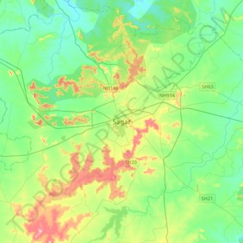
Name: Sagar topographic map, elevation, terrain.
Average elevation: 515 m
Minimum elevation: 461 m
Maximum elevation: 651 m
Thank you for supporting this site ❤️
Make a donation
Make a donation