
Ziro topographic map
Interactive map
Click on the map to display elevation.
About this map
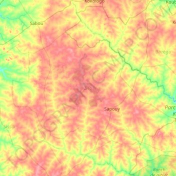
Name: Ziro topographic map, elevation, terrain.
Location: Ziro, Central-West, Burkina Faso (11.34254 -2.37409 12.00728 -1.30960)
Average elevation: 319 m
Minimum elevation: 266 m
Maximum elevation: 389 m
Other topographic maps
Click on a map to view its topography, its elevation and its terrain.
Bobo-Dioulasso
Bobo-Dioulasso, Houet, Upper-Basins, 00000, Burkina Faso
Average elevation: 388 m
Komoé River
Komoé River, Wolokonto, Léraba, Waterfalls, Burkina Faso
Average elevation: 456 m