
Thank you for supporting this site ❤️
Make a donation
Make a donation
Vellore topographic map
Click on the map to display elevation.
Thank you for supporting this site ❤️
Make a donation
Make a donation
Vellore
Vellore is at 12°55′N 79°08′E / 12.92°N 79.13°E / 12.92; 79.13, 220m above sea level. The city has a tropical savanna climate. It is in the Vellore district of the South Indian state, Tamil Nadu, 135 km (84 mi) west of the state capital Chennai and 30 km (19 mi) kms South of its twin city Chittoor, across the Andhra Pradesh border.Vellore lies in the Eastern Ghats region and Palar river basin. The topography is almost flat with slope from west to east.
Thank you for supporting this site ❤️
Make a donation
Make a donation
About this map
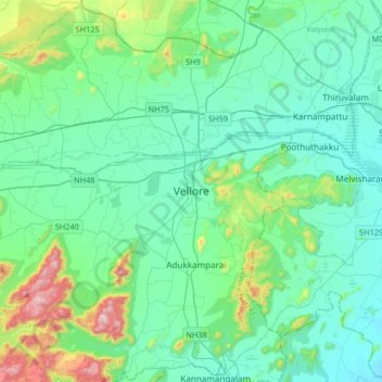
Name: Vellore topographic map, elevation, terrain.
Location: Vellore, Tamil Nadu, 632012, India (12.74718 78.97097 13.06718 79.29097)
Average elevation: 283 m
Minimum elevation: 153 m
Maximum elevation: 882 m
Thank you for supporting this site ❤️
Make a donation
Make a donation