
Namakkal topographic map
Interactive map
Click on the map to display elevation.
Namakkal
Namakkal is located at 11°14′N 78°10′E / 11.23°N 78.17°E / 11.23; 78.17. It has an average elevation of 218 metres or 715 feet. It is close to Kolli Hills – which are part of the Eastern Ghats. The closest significant river is the Kaveri and it is located 360 kilometres or 224 miles southwest of Chennai and 250 kilometres or 155 miles south of Bangalore.
About this map
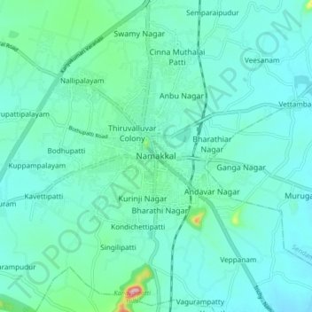
Name: Namakkal topographic map, elevation, terrain.
Location: Namakkal, Namakkal District, Tamil Nadu, 637001, India (11.17917 78.12787 11.25917 78.20787)
Average elevation: 192 m
Minimum elevation: 163 m
Maximum elevation: 354 m