
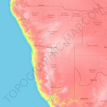
Namibia topographic map
Interactive map
Click on the map to display elevation.
About this map
Name: Namibia topographic map, elevation, terrain.
Location: Namibia (-28.96945 11.52804 -16.96351 25.26173)
Average elevation: 783 m
Minimum elevation: 0 m
Maximum elevation: 2,328 m
The Central Plateau runs from north to south, bordered by the Skeleton Coast to the northwest, the Namib Desert and its coastal plains to the southwest, the Orange River to the south, and the Kalahari Desert to the east. The Central Plateau is home to the highest point in Namibia at Königstein elevation 2,606 metres (8,550 ft).
Other topographic maps
Click on a map to view its topography, its elevation and its terrain.
India
India
Average elevation: 1,017 m
Montreal
Canada > Quebec > Urban agglomeration of Montreal > Montreal
Montreal, Urban agglomeration of Montreal, Montreal (06), Quebec, H3B 1M7, Canada
Average elevation: 30 m
Hyderabad
India > Telangana > Bahadurpura mandal
Hyderabad, Bahadurpura mandal, Hyderabad District, Telangana, India
Average elevation: 549 m
Snohomish County
Snohomish County, Washington, United States
Average elevation: 649 m
gehunlad
India > Uttarakhand > Chaubatta Khal
gehunlad, Chaubatta Khal, Pauri Garhwal District, Uttarakhand, India
Average elevation: 1,625 m
Thanjavur
India > Tamil Nadu > Thanjavur
Thanjavur, Thanjavur District, Tamil Nadu, 613001, India
Average elevation: 49 m
Sri Lanka
Sri Lanka
Average elevation: 50 m
Ocheretyne
Ocheretyne, Ocheretyne settlement hromada, Pokrovskii Raion, Donetsk Oblast, 86020, Ukraine
Average elevation: 227 m
Anaikatti
India > Tamil Nadu > Coimbatore North
Anaikatti, Mannarkad, Palakkad District, Kerala, 678741, India
Average elevation: 623 m
Pune
India > Maharashtra > Pune City > Pune
Pune, Pune City, Pune District, Maharashtra, 411001, India
Average elevation: 641 m
Tacoma
United States > Washington > Pierce County
Tacoma, Pierce County, Washington, United States
Average elevation: 67 m
Surat
India > Gujarat > Katargam Taluka > Surat
Surat, Katargam Taluka, Surat, Gujarat, 395001, India
Average elevation: 11 m
Delhi
India > Delhi > Kotwali Tehsil
Delhi, Kotwali Tehsil, Central Delhi, Delhi, 110006, India
Average elevation: 216 m
Bengaluru
India > Karnataka > Bangalore North
Bengaluru, Bangalore North, Bengaluru Urban District, Karnataka, India
Average elevation: 881 m
Shakarpur
India > Delhi > Gandhi Nagar Tehsil
Shakarpur, Gandhi Nagar Tehsil, East Delhi District, Delhi, India
Average elevation: 206 m
Clappana
India > Kerala > Karunagappally
Clappana, Karunagappally, Kollam District, Kerala, 690525, India
Average elevation: 5 m
Dahej
India > Gujarat > Vagra Taluka
Dahej, Vagra Taluka, Bharuch District, Gujarat, 393125, India
Average elevation: 6 m
Kandy
Kandy, Kandy District, Central Province, 20000, Sri Lanka
Average elevation: 621 m
Siliguri
India > West Bengal > Siliguri Subdivsion
Siliguri, Siliguri Subdivsion, Darjeeling District, West Bengal, India
Average elevation: 121 m
Warud
India > Maharashtra > Buldhana
Warud, Buldhana, Buldhana District, Maharashtra, India
Average elevation: 594 m
Badroud
Iran > Isfahan Province > Natanz County
Badroud, بخش امامزاده, Natanz County, Isfahan Province, 87661-37751, Iran
Average elevation: 994 m
Naula
India > Uttarakhand > Bhanoli
Naula, Bhanoli, Almora District, Uttarakhand, India
Average elevation: 1,562 m
Rajmachi Fort
India > Maharashtra > Mawal > Udhewadi
Rajmachi Fort, Udhewadi, Mawal, Pune District, Maharashtra, India
Average elevation: 501 m
Pura
Indonesia > East Nusa Tenggara > Alor
Pura, Alor, East Nusa Tenggara, Lesser Sunda Islands, Indonesia
Average elevation: 275 m
Malhargad Fort
India > Maharashtra > Purandhar
Malhargad Fort, Malhargad Walking Path, Purandhar, Pune District, Maharashtra, India
Average elevation: 822 m
Visapur Fort
India > Maharashtra > Mawal > Patan
Visapur Fort, Bhatrishi peak, Patan, Mawal, Pune District, Maharashtra, 410401, India
Average elevation: 818 m
Gladstone Regional
Gladstone Regional, Queensland, Australia
Average elevation: 116 m
Mount Maria
Mount Maria, Toowoomba Regional, Queensland, Australia
Average elevation: 382 m
Dadholi
India > Uttarakhand > Dwarahat
Dadholi, Dwarahat, Almora District, Uttarakhand, 263654, India
Average elevation: 1,449 m
Sinhagad Vikas Udyan
India > Maharashtra > Pune
Sinhagad Vikas Udyan, Vadgaon Budruk, Pune, Pune District, Maharashtra, 411051, India
Average elevation: 580 m
City of Medan
City of Medan, North Sumatra, Sumatra, Indonesia
Average elevation: 18 m
Asundi
India > Karnataka > Bellary taluk
Asundi, Bellary taluk, Ballari District, Karnataka, India
Average elevation: 419 m
Mandi
India > Himachal Pradesh > Mandi
Mandi, Mandi District, Himachal Pradesh, 175001, India
Average elevation: 1,273 m
Kanyakumari district
Kanyakumari district, Tamil Nadu, India
Average elevation: 226 m
Haywood County
United States > North Carolina
Haywood County, North Carolina, United States
Average elevation: 1,044 m
Bhatwari
Bhatwari, Uttarkashi District, Uttarakhand, India
Average elevation: 4,570 m
Musi River
Musi River, Hyderabad, Uppal mandal, Medchal–Malkajgiri, Telangana, 5000036, India
Average elevation: 490 m