
United Arab Emirates topographic map
Interactive map
Click on the map to display elevation.
About this map
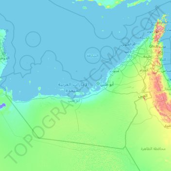
Name: United Arab Emirates topographic map, elevation, terrain.
Location: United Arab Emirates (22.63162 51.41607 26.15172 56.60245)
Average elevation: 85 m
Minimum elevation: -15 m
Maximum elevation: 2,000 m
The climate of the UAE is subtropical-arid with hot summers and warm winters. The climate is categorized as desert climate. The hottest months are July and August, when average maximum temperatures reach above 45 °C (113 °F) on the coastal plain. In the Al Hajar Mountains, temperatures are considerably lower, a result of increased elevation. Average minimum temperatures in January and February are between 10 and 14 °C (50 and 57 °F). During the late summer months, a humid southeastern wind known as Sharqi (i.e. "Easterner") makes the coastal region especially unpleasant. The average annual rainfall in the coastal area is less than 120 mm (4.7 in), but in some mountainous areas annual rainfall often reaches 350 mm (13.8 in). Rain in the coastal region falls in short, torrential bursts during the winter months, sometimes resulting in floods in ordinarily dry wadi beds. The region is prone to occasional, violent dust storms, which can severely reduce visibility.
Other topographic maps
Click on a map to view its topography, its elevation and its terrain.
Montreal
Canada > Quebec > Urban agglomeration of Montreal > Montreal
Montreal, Urban agglomeration of Montreal, Montreal (06), Quebec, H3B 1M7, Canada
Average elevation: 30 m
India
India
Average elevation: 1,017 m
Tacoma
United States > Washington > Pierce County
Tacoma, Pierce County, Washington, United States
Average elevation: 67 m
Bengaluru
India > Karnataka > Bangalore North
Bengaluru, Bangalore North, Bengaluru Urban District, Karnataka, India
Average elevation: 881 m
Sri Lanka
Sri Lanka
Average elevation: 50 m
Hyderabad
India > Telangana > Bahadurpura mandal
Hyderabad, Bahadurpura mandal, Hyderabad District, Telangana, India
Average elevation: 549 m
Kandy
Kandy, Kandy District, Central Province, 20000, Sri Lanka
Average elevation: 621 m
Vairavanpatti
India > Tamil Nadu > Thiruppathur
Vairavanpatti, Thiruppathur, Sivagangai District, Tamil Nadu, 630207, India
Average elevation: 103 m
saraikhet
India > Uttarakhand > Dhoomakot
saraikhet, Dhoomakot, Pauri Garhwal District, Uttarakhand, India
Average elevation: 1,861 m
Dudori
India > Uttarakhand > Syalde > Kaljipa
Dudori, Kaljipa, Syalde, Almora District, Uttarakhand, 263665, India
Average elevation: 1,564 m
Bourne
United States > Massachusetts > Barnstable County
Bourne, Barnstable County, Massachusetts, United States
Average elevation: 20 m
Dexter Canyon
United States > California > Santa Clara County
Dexter Canyon, Santa Clara County, California, United States
Average elevation: 529 m
Haywood County
United States > North Carolina
Haywood County, North Carolina, United States
Average elevation: 1,044 m
Vadodara
India > Gujarat > Vadodara Taluka
Vadodara, Vadodara Taluka, Vadodara District, Gujarat, 390001, India
Average elevation: 36 m
Surat
India > Gujarat > Katargam Taluka > Surat
Surat, Katargam Taluka, Surat, Gujarat, 395001, India
Average elevation: 11 m
Nepal
Nepal
Average elevation: 2,604 m
Bajwad
India > Uttarakhand > Garud
Bajwad, Garud, Bageshwar District, Uttarakhand, India
Average elevation: 1,755 m
Gilroy Hot Springs
United States > California > Santa Clara County
Gilroy Hot Springs, Santa Clara County, California, United States
Average elevation: 525 m
Mangaluru
India > Karnataka > Mangaluru taluk
Mangaluru, Mangaluru taluk, Dakshina Kannada District, Karnataka, 575001, India
Average elevation: 25 m
Siliguri
India > West Bengal > Siliguri Subdivsion
Siliguri, Siliguri Subdivsion, Darjeeling District, West Bengal, India
Average elevation: 121 m
Dehradun
India > Uttarakhand > Dehradun
Dehradun, Dehradun District, Uttarakhand, 248001, India
Average elevation: 904 m
Pune
India > Maharashtra > Pune City > Pune
Pune, Pune City, Pune District, Maharashtra, 411001, India
Average elevation: 641 m
Anaikatti
India > Tamil Nadu > Coimbatore North
Anaikatti, Mannarkad, Palakkad District, Kerala, 678741, India
Average elevation: 623 m
Bhatwari
Bhatwari, Uttarkashi District, Uttarakhand, India
Average elevation: 4,570 m
Snohomish County
Snohomish County, Washington, United States
Average elevation: 649 m
Sirpur
India > Chhattisgarh > Mahasamund Tahsil
Sirpur, Mahasamund Tahsil, Mahasamund District, Chhattisgarh, India
Average elevation: 255 m
Udaipur
India > Rajasthan > Girwa Tehsil
Udaipur, Girwa Tehsil, Udaipur District, Rajasthan, 313001, India
Average elevation: 656 m
Chennai
India > Tamil Nadu > Chennai
Chennai, Chennai District, Tamil Nadu, India
Average elevation: 8 m
Boa Viagem
Boa Viagem, Região Geográfica Imediata de Canindé, Região Geográfica Intermediária de Fortaleza, Ceará, Northeast Region, 63870-000, Brazil
Average elevation: 399 m
Asundi
India > Karnataka > Bellary taluk
Asundi, Bellary taluk, Ballari District, Karnataka, India
Average elevation: 419 m
Yalpi
India > Karnataka > Bellary taluk
Yalpi, Bellary taluk, Ballari District, Karnataka, India
Average elevation: 419 m
Konchigeri
India > Karnataka > Siruguppa taluku
Konchigeri, Siruguppa taluku, Ballari District, Karnataka, 583120, India
Average elevation: 421 m
Tanunda
Tanunda, The Barossa Council, South Australia, 5352, Australia
Average elevation: 276 m
Aspur
India > Rajasthan > Aspur Tehsil
Aspur, Aspur Tehsil, Dungarpur District, Rajasthan, 314021, India
Average elevation: 223 m
Sabla
India > Rajasthan > Sabla Tehsil
Sabla, Sabla Tehsil, Dungarpur District, Rajasthan, 314022, India
Average elevation: 177 m
Bhemai
India > Rajasthan > Galiakot Tehsil
Bhemai, Galiakot Tehsil, Dungarpur District, Rajasthan, India
Average elevation: 187 m
Gowari
India > Rajasthan > Sagwara Tehsil
Gowari, Sagwara Tehsil, Dungarpur District, Rajasthan, India
Average elevation: 178 m
Kariyana
India > Rajasthan > Sagwara Tehsil
Kariyana, Sagwara Tehsil, Dungarpur District, Rajasthan, 314032, India
Average elevation: 167 m
Sagwara
India > Rajasthan > Sagwara Tehsil
Sagwara, Sagwara Tehsil, Dungarpur District, Rajasthan, 314025, India
Average elevation: 177 m