
Make a donation
Thrissur topographic map
Click on the map to display elevation.
Make a donation
Thrissur
Thrissur is the headquarters of Thrissur district, in the centre of the Indian state of Kerala. The city is 75 km north-east of Kochi, 133 km south-west of Coimbatore, 124 km south-east of Kozhikode and 151 km north of Changanacherry. The city is located in a hillock called Thekkinkadu Maidan which is the second highest point in city after the Vilangan Hills. The city has an average altitude of 2.83 metres above sea level.
Make a donation
About this map
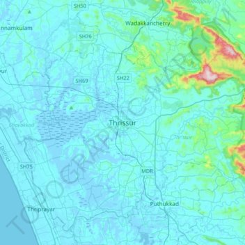
Name: Thrissur topographic map, elevation, terrain.
Location: Thrissur, Kerala, 680001, India (10.36701 76.05462 10.68701 76.37462)
Average elevation: 36 m
Minimum elevation: -6 m
Maximum elevation: 516 m
Make a donation
Other topographic maps
Click on a map to view its topography, its elevation and its terrain.
Make a donation
Make a donation
Make a donation
Kulam -Balakrishnan,Karamangattil, Chazhoor, Chetakulam
India > Kerala > Thrissur > Puthenpeedika
Average elevation: 6 m
Make a donation
Make a donation