
Quetta topographic map
Interactive map
Click on the map to display elevation.
About this map
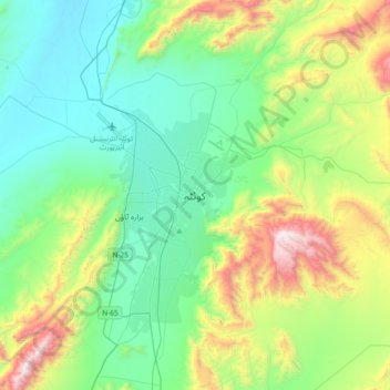
Name: Quetta topographic map, elevation, terrain.
Location: Quetta, Mastung District, Balochistan, 87300, Pakistan (30.03574 66.85725 30.35574 67.17725)
Average elevation: 1,968 m
Minimum elevation: 1,538 m
Maximum elevation: 3,180 m
Quetta (Pashto: کوټه Kwaṭa; Balochi: کویته; Hazaragi: کوٹه; Urdu: کوئٹہ; (listen); formerly known as Shalkot (Pashto: شالکوټ) is the provincial capital and largest city of Balochistan, Pakistan. It is also the 10th largest city of Pakistan. It was largely destroyed in the 1935 Quetta earthquake, but was rebuilt and has a population of 1,001,205 according to the census of 2017. Quetta is at an average elevation of 1,680 metres (5,510 feet) above sea level, making it Pakistan's only high-altitude major city. The city is known as the "Fruit Garden of Pakistan," due to the numerous fruit orchards in and around it, and the large variety of fruits and dried fruit products produced there.
Other topographic maps
Click on a map to view its topography, its elevation and its terrain.
Hanna Lake
Pakistan > Balochistan > Quetta
Hanna Lake, Quetta Road, Cantonment, Quetta, Ziārat District, Balochistan, 87300, Pakistan
Average elevation: 1,957 m