
Dwarka topographic map
Interactive map
Click on the map to display elevation.
Dwarka
Considered a holy city, Dwarka is well known for its temples and as a pilgrimage centre for Hindus. The Dwarakadhisa Temple, also called Jagat Mandir, located in the heart of Dwarka, is a Vaishnava temple. It was built by Raja Jagat Singh Rathore, hence it is called Jagat Mandir. The temple, facing west, is at an elevation of 12.19 metres (40.0 ft) above mean sea-level. It is conjectured that this temple location is 2,500 years old and is where Krishna built his city and a temple. However, the existing temple is dated to the 16th century. It is a five-storied edifice built over 72 pillars (a sandstone temple with 60 pillars is also mentioned). The temple spire rises to a height of 78 metres (256 ft), and a very large flag with symbols of the sun and moon is hoisted on it. The temple layout consists of a garbhagriha (Nijamandira or Harigraha) and an antarala (an antechamber). The main deity deified in the sanctum is Dwarkadeesh, which is known as the Trivikrama form of Vishnu and is depicted with four arms.
About this map
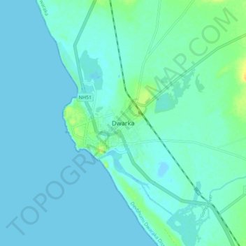
Name: Dwarka topographic map, elevation, terrain.
Average elevation: 3 m
Minimum elevation: -1 m
Maximum elevation: 17 m
Other topographic maps
Click on a map to view its topography, its elevation and its terrain.