
Tromsø topographic map
Interactive map
Click on the map to display elevation.
About this map
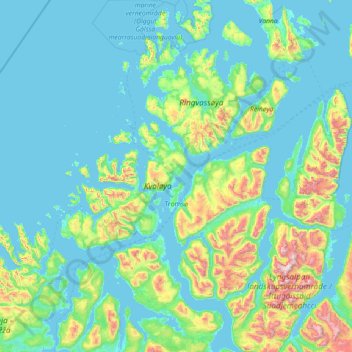
Name: Tromsø topographic map, elevation, terrain.
Location: Tromsø, Troms og Finnmark, Norway (69.28209 17.16005 70.16842 20.04364)
Average elevation: 193 m
Minimum elevation: -3 m
Maximum elevation: 1,817 m
Outside the city, large areas in the municipality are at some altitude and above the treeline with an alpine tundra climate (ET). The islands to the west at the outer seabord are milder in winter like Måsvik, making this part of the municipality a subpolar oceanic climate (Cfc) zone. The average date for first overnight freeze (temperature below −0 °C (32 °F) in autumn is October 3 (1981-2010 average).[39]