
Alappuzha topographic map
Interactive map
Click on the map to display elevation.
About this map
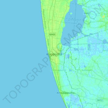
Name: Alappuzha topographic map, elevation, terrain.
Average elevation: 2 m
Minimum elevation: -6 m
Maximum elevation: 22 m
Alappuzha is located at 9°32′N 76°24′E / 9.54°N 76.40°E / 9.54; 76.40. The average elevation is 1 metre (3.3 ft) Alappuzha covers an area of 1,414 square kilometres (546 sq mi) and is flanked by 2,195 square kilometres (847 sq mi) of Vembanad Lake, where six major rivers spread out before joining the 80 km coast line of the district. The city of Alappuzha is crisscrossed by a system of canals, which is a part of the National Waterway 3.
Other topographic maps
Click on a map to view its topography, its elevation and its terrain.
Paravoor
India > Kerala > Ambalappuzha
Paravoor, Ambalappuzha, Alappuzha, Kerala, 688014, India
Average elevation: 5 m
Punnamada Lake
India > Kerala > Ambalappuzha > Alappuzha
Punnamada Lake, Mullakkal, Alappuzha, Ambalappuzha, Alappuzha, Kerala, 688001, India
Average elevation: 5 m