
Purulia - II topographic map
Interactive map
Click on the map to display elevation.
About this map
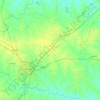
Name: Purulia - II topographic map, elevation, terrain.
Location: Purulia - II, Puruliya, West Bengal, India (23.26134 86.30520 23.48135 86.52287)
Average elevation: 230 m
Minimum elevation: 184 m
Maximum elevation: 354 m
The Purulia II CD block is located in the central part of the district. The Kangsabati River forms the boundary between the Purulia II and Purulia I CD blocks. The upper Kangsabati basin has undulating land and the elevation rises from 200 to 300 m and the general slope is from west to east and south-east.
Other topographic maps
Click on a map to view its topography, its elevation and its terrain.
Purulia
India > West Bengal > Purulia - II
Purulia, Purulia - II, Puruliya, West Bengal, 723101, India
Average elevation: 241 m