
Wörschweiler topographic map
Interactive map
Click on the map to display elevation.
About this map
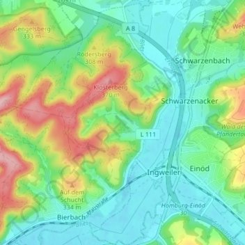
Name: Wörschweiler topographic map, elevation, terrain.
Location: Wörschweiler, Homburg, Saarpfalz-Kreis, Saarland, Deutschland (49.25809 7.28056 49.30179 7.31329)
Average elevation: 269 m
Minimum elevation: 215 m
Maximum elevation: 385 m
Wörschweiler liegt ca. 4 km südwestlich von Homburg im Tal der Blies auf einer Höhe von 227 m ü. NHN. Nachbarorte sind Bierbach, Schwarzenacker, Beeden und Limbach. Der Ort wird von der Autobahn 8 tangiert.
Other topographic maps
Click on a map to view its topography, its elevation and its terrain.
Erbach
Deutschland > Saarland > Homburg
Erbach, Homburg, Saarpfalz-Kreis, Saarland, Deutschland
Average elevation: 254 m
Eichelscheid
Deutschland > Saarland > Homburg
Eichelscheid, Bruchhof-Sanddorf, Homburg, Saarpfalz-Kreis, Saarland, Deutschland
Average elevation: 258 m
Kirrberg
Deutschland > Saarland > Homburg
Kirrberg, Homburg, Saarpfalz-Kreis, Saarland, Deutschland
Average elevation: 306 m
Websweiler
Deutschland > Saarland > Homburg
Websweiler, Jägersburg, Homburg, Saarpfalz-Kreis, Saarland, Deutschland
Average elevation: 349 m