
Kosi River topographic map
Interactive map
Click on the map to display elevation.
About this map
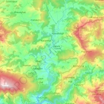
Name: Kosi River topographic map, elevation, terrain.
Location: Kosi River, Almora, Uttarakhand, 263600, India (29.55274 79.60191 29.68657 79.64754)
Average elevation: 1,436 m
Minimum elevation: 1,041 m
Maximum elevation: 2,185 m
Other topographic maps
Click on a map to view its topography, its elevation and its terrain.
Almora
India > Uttarakhand > Almora
Almora is located at 29°35′50″N 79°39′33″E / 29.5971°N 79.6591°E / 29.5971; 79.6591 in Almora district in Uttarakhand. Almora is situated 365 km north-east the national capital New Delhi and 415 km south-east the state capital Dehradun. It lies in the revenue Division Kumaon and is located…
Average elevation: 1,557 m