
Ambur topographic map
Interactive map
Click on the map to display elevation.
About this map
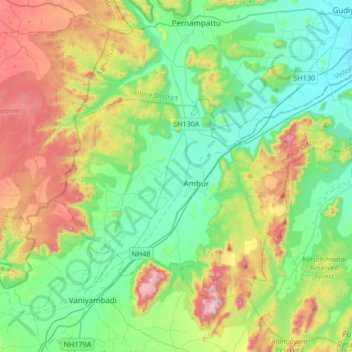
Name: Ambur topographic map, elevation, terrain.
Location: Ambur, Tirupattur District, Tamil Nadu, India (12.67698 78.58122 12.91090 78.91688)
Average elevation: 473 m
Minimum elevation: 266 m
Maximum elevation: 938 m
Other topographic maps
Click on a map to view its topography, its elevation and its terrain.
Pachaikuppam
India > Tamil Nadu > Ambur
Pachaikuppam, Ambur, Tirupattur District, Tamil Nadu, India
Average elevation: 363 m
Gollapuram
India > Tamil Nadu > Ambur > Gollapuram
Gollapuram, Ambur, Tirupattur District, Tamil Nadu, 635813, India
Average elevation: 326 m