
North Western Province topographic map
Interactive map
Click on the map to display elevation.
North Western Province
The North Western Province is characterised by a variety of topographical and climatic conditions, ranging from coastal regions with a tropical climate to inland areas that experience a more varied climate. The region features several prominent water bodies, including the Puttalam Lagoon, Mundal Lagoon, and the Deduru Oya. Other significant rivers in the province include the Mee Oya and the Kala Oya rivers. The province also contains a portion of the Wilpattu National Park, one of the largest and oldest national parks in Sri Lanka, known for its diverse wildlife and natural beauty.
About this map
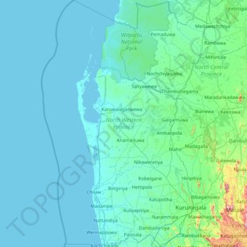
Name: North Western Province topographic map, elevation, terrain.
Location: North Western Province, Sri Lanka (7.25789 79.49072 8.68869 80.57792)
Average elevation: 66 m
Minimum elevation: 0 m
Maximum elevation: 1,167 m
Other topographic maps
Click on a map to view its topography, its elevation and its terrain.
Kandy
Kandy is located in the mountainous and thickly forested interior of the island. The city is located in between multiple mountain ranges including the Knuckles mountain range and the Hanthana Mountain Range, giving the city an elevation of 500 metres (1,600 ft) above sea level. It lies adjacent to the…
Average elevation: 621 m
Morapitiya
Sri Lanka > Western Province > Palinda-Nuwara (Baduraliya) DS Division
Average elevation: 77 m
Ambalangoda
Situated approximately 87 kilometres (54 mi) south of Colombo, it sits on an elevation of 13 metres (43 ft) above the sea level.
Average elevation: 4 m