
Central Province topographic map
Interactive map
Click on the map to display elevation.
About this map
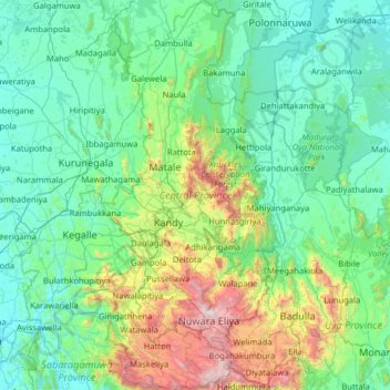
Name: Central Province topographic map, elevation, terrain.
Location: Central Province, Sri Lanka (6.75122 80.42190 8.01235 81.01653)
Average elevation: 389 m
Minimum elevation: 8 m
Maximum elevation: 2,493 m
Other topographic maps
Click on a map to view its topography, its elevation and its terrain.
Kandy
Kandy is located in the mountainous and thickly forested interior of the island. The city is located in between multiple mountain ranges including the Knuckles mountain range and the Hanthana Mountain Range, giving the city an elevation of 500 metres (1,600 ft) above sea level. It lies adjacent to the…
Average elevation: 621 m
Rakwana
Sri Lanka > Sabaragamuwa Province
Located at an elevation of 464 m (1,522 ft), north of Sinharaja Mountains, on the A17 highway. It is 12 km (7.5 mi) from Rakwana-Deniyaya on the way to Galle. It also has roads leading to Embilipitiya and Kalawana. Rakwana acts as one of the gateways for the famous Sinharaja Forest reserve.
Average elevation: 609 m
Kandy
Kandy is located in the mountainous and thickly forested interior of the island. The city is located in between multiple mountain ranges including the Knuckles mountain range and the Hanthana Mountain Range, giving the city an elevation of 500 metres (1,600 ft) above sea level. It lies adjacent to the…
Average elevation: 621 m
Kurana
Kurana is a municipal ward of Negombo, Sri Lanka. It is on the Negombo-Colombo Main road and is located a few miles from the Bandaranaike International Airport. It has an average elevation of 7 m (23 ft) above sea level.
Average elevation: 7 m