
Palakkad topographic map
Interactive map
Click on the map to display elevation.
About this map
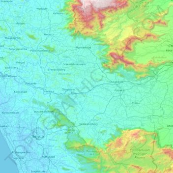
Name: Palakkad topographic map, elevation, terrain.
Location: Palakkad, Kerala, India (10.33493 76.02672 11.23973 76.90774)
Average elevation: 306 m
Minimum elevation: -5 m
Maximum elevation: 2,431 m
Palakkad is the gateway to Kerala due to the presence of the Palakkad Gap, in the Western Ghats. The total area of the district is 4,480 km2 (1,730 sq mi) which is 11.5% of the state's area which makes it the largest district of Kerala. Out of the total area of 4,480 km2 (1,730 sq mi), about 1,360 km2 (530 sq mi) of land is covered by forests. Most parts of the district fall in the midland region (elevation 75–250 m or 246–820 ft), except the Nelliampathy-Parambikulam area in the Chittur taluk in the south and Attappadi-Malampuzha area in the north, which are hilly and fall in the highland region (elevation > 250 m or 820 ft).
Other topographic maps
Click on a map to view its topography, its elevation and its terrain.
Kuvalettam
Kuvalettam, Peerumade, Idukki District, Kerala, 685503, India
Average elevation: 979 m
Chempakapara
India > Kerala > Udumbanchola > Chempakappara > Kochukamakshy
Chempakapara, Kochukamakshy, Chempakappara, Udumbanchola, Idukki District, Kerala, India
Average elevation: 811 m
Thiruvananthapuram
India > Kerala > Thiruvananthapuram
Thiruvananthapuram, Thiruvananthapuram District, Kerala, 695001, India
Average elevation: 33 m
Kattadikavala
India > Kerala > Peerumade > Cheenthalar
Kattadikavala, Cheenthalar, Peerumade, Idukki District, Kerala, 685501, India
Average elevation: 864 m
Ponkunnam
India > Kerala > Kanjirappally
Ponkunnam, Kanjirappally, Kottayam District, Kerala, 686519, India
Average elevation: 83 m
Gurukula Botanical Sanctuary
India > Kerala > Mananthavady > Periya
Gurukula Botanical Sanctuary, Periya - Valad Road, Periya, Mananthavady, Wayanad District, Kerala, 670552, India
Average elevation: 756 m
Prakkanam
India > Kerala > Kozhencherry > Prakkanam
Prakkanam, Kozhencherry, Pathanamthitta District, Kerala, India
Average elevation: 58 m
Kariyam
India > Kerala > Thiruvananthapuram
Kariyam, Thiruvananthapuram, Thiruvananthapuram District, Kerala, 695588, India
Average elevation: 40 m
Nayarambalam
Nayarambalam, Kochi, Ernakulam District, Kerala, 682509, India
Average elevation: 3 m
Athirappilly
India > Kerala > Chalakkudy
Athirappilly, Chalakkudy, Thrissur District, Kerala, India
Average elevation: 406 m
Edakkal
India > Kerala > Sulthanbathery > Ambalavayal
Edakkal, Ambalavayal, Sulthanbathery, Wayanad District, Kerala, India
Average elevation: 927 m
Poozhikunn Colony
India > Kerala > Kattakkada
Poozhikunn Colony, Kattakkada, Thiruvananthapuram District, Kerala, 695510, India
Average elevation: 61 m
Velliyamparambu
India > Kerala > Thalassery
Velliyamparambu, Thalassery, Kannur District, Kerala, 670708, India
Average elevation: 63 m
Mariyapuram
Mariyapuram, Idukki, Idukki District, Kerala, 685602, India
Average elevation: 687 m
Vattappara
India > Kerala > Nedumangad
Vattappara, Nedumangad, Thiruvananthapuram District, Kerala, 695028, India
Average elevation: 87 m
Kalathilakkara
India > Kerala > Perinthalmanna > Chollonkunnu
Kalathilakkara, Chollonkunnu, Perinthalmanna, Malappuram District, Kerala, India
Average elevation: 89 m
Powdiconam or Society Mukku
India > Kerala > Thiruvananthapuram
Powdiconam or Society Mukku, Thiruvananthapuram, Thiruvananthapuram District, Kerala, India
Average elevation: 46 m
Vadakkanad
India > Kerala > Sulthanbathery
Vadakkanad, Sulthanbathery, Wayanad District, Kerala, India
Average elevation: 896 m
Kariyathumpara
India > Kerala > Koyilandi > Vallayil Thazhe
Kariyathumpara, Vallayil Thazhe, Koyilandi, Kozhikode District, Kerala, India
Average elevation: 199 m
Madathara
India > Kerala > Kottarakkara
Madathara, Kottarakkara, Kollam District, Kerala, 691541, India
Average elevation: 180 m
Chethonkara
Chethonkara, Ranni, Pathanamthitta District, Kerala, 689675, India
Average elevation: 59 m
Vellanad
India > Kerala > Kattakkada > Uriyacode
Vellanad, Uriyacode, Kattakkada, Thiruvananthapuram District, Kerala, India
Average elevation: 77 m
Ravaneshwaram
India > Kerala > Hosdurg > Veleswaram
Ravaneshwaram, Veleswaram, Hosdurg, Kasaragod District, Kerala, 671329, India
Average elevation: 26 m
Kulappully
India > Kerala > Ottappalam
Kulappully, Ottappalam, Palakkad District, Kerala, 679122, India
Average elevation: 56 m
Vazhakulam
India > Kerala > Muvattupuzha
Vazhakulam, Muvattupuzha, Ernakulam District, Kerala, 686670, India
Average elevation: 41 m
Elivalikkara
India > Kerala > Kanjirappally > Mukkoottuthara
Elivalikkara, Mukkoottuthara, Kanjirappally, Kottayam District, Kerala, India
Average elevation: 167 m
Chavassery
Chavassery, Iritty, Kannur District, Kerala, 670702, India
Average elevation: 71 m
Willingdon Island
India > Kerala > Kochi > Kochi
Willingdon Island, Kochi, Ernakulam District, Kerala, India
Average elevation: 4 m
Senapathy
India > Kerala > Udumbanchola
Senapathy, Udumbanchola, Idukki District, Kerala, 685619, India
Average elevation: 1,051 m
Champakulam
Champakulam, Kuttanad, Alappuzha District, Kerala, 688505, India
Average elevation: 3 m
Kalamassery
India > Kerala > Kanayannur
Kalamassery, Kanayannur, Ernakulam District, Kerala, 683104, India
Average elevation: 9 m
Sarovaram Bio Park
India > Kerala > Kozhikode > Erenjippalam
Sarovaram Bio Park, Mini Bypass Road, Jawahar Nagar, Erenjippalam, Kozhikode, Kozhikode District, Kerala, 673004, India
Average elevation: 14 m
Nellarachal
India > Kerala > Sulthanbathery
Nellarachal, Sulthanbathery, Wayanad District, Kerala, India
Average elevation: 781 m
Thoppipala
India > Kerala > Idukki > Labbakada
Thoppipala, Labbakada, Idukki, Idukki District, Kerala, 685511, India
Average elevation: 842 m