
Teton County topographic map
Interactive map
Click on the map to display elevation.
About this map
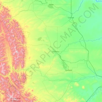
Name: Teton County topographic map, elevation, terrain.
Location: Teton County, Montana, United States (47.50015 -113.01481 48.13309 -111.40884)
Average elevation: 1,368 m
Minimum elevation: 909 m
Maximum elevation: 2,757 m
Other topographic maps
Click on a map to view its topography, its elevation and its terrain.
Kalispell
United States > Montana > Flathead County > Kalispell
Kalispell is located at 48°11′52″N 114°18′58″W / 48.19778°N 114.31611°W / 48.19778; -114.31611 (48.197801, −114.316068), at an elevation of 2,956 feet (901 m).
Average elevation: 1,055 m
Bozeman
United States > Montana > Gallatin County > Bozeman
Bozeman is located at an elevation of 4,820 feet (1,470 m). The Bridger Mountains are to the north-northeast, the Tobacco Root Mountains to the west-south-west, the Big Belt Mountains and Horseshoe Hills to the northwest, the Hyalite Peaks of the northern Gallatin Range to the south and the Spanish Peaks of…
Average elevation: 1,679 m