
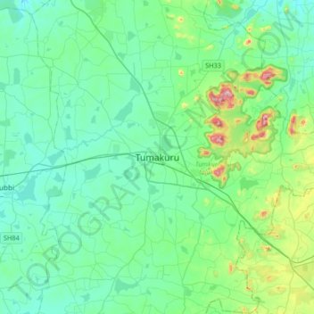
Tumakuru topographic map
Interactive map
Click on the map to display elevation.
About this map
Name: Tumakuru topographic map, elevation, terrain.
Average elevation: 838 m
Minimum elevation: 752 m
Maximum elevation: 1,243 m
Tumkur, officially renamed as Tumakuru, is a city located in the southern part of Indian state of Karnataka. Tumkur is situated at a distance of 70 km (43 mi) northwest of Bangalore, the state capital along NH 48 and NH 73. It is the headquarters of the Tumkur district. It is located at an altitude of 835 m (2739.5 ft).
Other topographic maps
Click on a map to view its topography, its elevation and its terrain.
Vaderapura
India > Karnataka > Tumkur taluk
Vaderapura, Tumkur taluk, Tumakuru District, Karnataka, India
Average elevation: 819 m
Kaidala
India > Karnataka > Tumkur taluk > Kaidala
Kaidala, Tumkur taluk, Tumkur district, Karnataka, 572105, India
Average elevation: 807 m