
Kurduvadi topographic map
Interactive map
Click on the map to display elevation.
Kurduvadi
Kurduvadi is located at 18°05′N 75°26′E / 18.08°N 75.43°E / 18.08; 75.43. It has an average elevation of 502 metres (1646 feet).
About this map
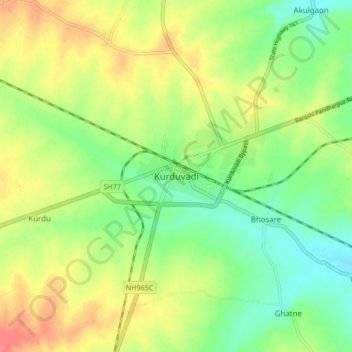
Name: Kurduvadi topographic map, elevation, terrain.
Location: Kurduvadi, Madha, Solapur, Maharashtra, 413230, India (18.05077 75.37394 18.13077 75.45394)
Average elevation: 520 m
Minimum elevation: 495 m
Maximum elevation: 550 m