
Gunnison County topographic map
Interactive map
Click on the map to display elevation.
Gunnison County
Gunnison County is the fifth-most extensive of the 64 counties in the U.S. state of Colorado. As of the 2010 census, the population was 15,324. The county seat is Gunnison. The county was named for John W. Gunnison, a United States Army officer and captain in the Army Topographical Engineers, who surveyed for the transcontinental railroad in 1853.
About this map
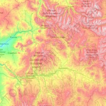
Name: Gunnison County topographic map, elevation, terrain.
Location: Gunnison County, Colorado, United States (38.14707 -107.63504 39.25769 -106.24563)
Average elevation: 2,892 m
Minimum elevation: 1,613 m
Maximum elevation: 4,388 m
Other topographic maps
Click on a map to view its topography, its elevation and its terrain.
Evergreen
United States > Colorado > Jefferson County
Evergreen sits at an elevation of 7,220 feet (2,200 m) in the Rocky Mountains, 19 miles west of Denver, Colorado. Its addresses are oriented according to the Street_system_of_Denver.
Average elevation: 2,309 m
Estes Park
United States > Colorado > Larimer County
Estes Park sits at an elevation of 7,522 feet (2,293 m) on the front range of the Rocky Mountains at the eastern entrance of the Rocky Mountain National Park. Its north, south and east extremities border the Roosevelt National Forest. Lumpy Ridge lies immediately north of Estes Park.
Average elevation: 2,543 m
Crested Butte
United States > Colorado > Gunnison County
Crested Butte is located in north-central Gunnison County on the west side of the valley of the Slate River, along Coal Creek. Colorado State Highway 135 runs south from Crested Butte 27 miles (43 km) to Gunnison, the county seat. According to the United States Census Bureau, the town of Crested Butte has a…
Average elevation: 2,798 m
Saint Elmo
United States > Colorado > Chaffee County
Saint Elmo is a ghost town in Chaffee County, Colorado, United States. Founded in 1880, Saint Elmo lies in the heart of the Sawatch Range, 20 miles (32 km) southwest of Buena Vista and sits at an elevation of 9,961 feet (3,036 m). Nearly 2,000 people settled in this town when mining for gold and silver…
Average elevation: 3,247 m
Pikes Peak
United States > Colorado > El Paso County
Soils on Pikes Peak above the timberline (approximately 12,000 ft or 3,700 m) are classified as Cirque land. Forests at lower altitudes mostly lie over the brown stony, sandy, loams of the Catamount loam or Ivywild loam series.
Average elevation: 3,902 m
Fairplay
United States > Colorado > Park County
The historic Town of Fairplay is the Statutory Town that is the county seat and the most populous municipality of Park County, Colorado, United States. The town population was 724 at the 2020 United States Census. Fairplay is located in South Park at an elevation of 9,953 feet (3,034 m). The town is the…
Average elevation: 3,045 m
Lakewood
United States > Colorado > Jefferson County > Lakewood
Lakewood is located at 39°42′17″N 105°04′53″W / 39.70472°N 105.08139°W / 39.70472; -105.08139 at an elevation of 5,518 feet (1,682 m). Located at the junction of U.S. Route 6 and Colorado State Highway 121 in central Colorado, the city lies immediately west of Denver and 62 miles (100 km)…
Average elevation: 1,717 m
Vail
United States > Colorado > Eagle County
Vail's average elevation is 8,150 feet (2484 m) above sea level. The town has a total area of 4.5 square miles (12 km2), with no lakes (there is, however, at least one pond). Gore Creek flows from east to west through the center of town.
Average elevation: 2,953 m
Mount Elbert
United States > Colorado > Lake County
Mount Elbert is the highest summit of the Rocky Mountains of North America. With an elevation of 14,438 feet (4400.58 m), it is also the highest point in the U.S. state of Colorado and the second-highest summit in the contiguous United States after Mount Whitney, which is slightly taller. The ultra-prominent…
Average elevation: 3,959 m
Grand Lake
United States > Colorado > Grand County
Established in 1881, Grand Lake sits at an elevation of 8,369 feet (2,551 m) and derives its name from the lake on whose shores it is situated: Grand Lake, the largest natural body of water in Colorado. The town of Grand Lake was originally an outfitting and supply point for the mining settlements of Lulu…
Average elevation: 2,630 m
Monument
United States > Colorado > El Paso County
Monument experiences a hemiboreal continental climate (Köppen Dfb) with warm, relatively rainy summers and cold, snowy winters. The semi-arid climate keeps the dew point very low in Monument year-round which causes the air to feel quite dry. Monument is part of the Front Range urban corridor and lies on the…
Average elevation: 2,160 m
Crestone Peak
United States > Colorado > Saguache County
Generally climbs of Crestone Peak or Crestone Needle start from a base camp at South Colony Lakes, east of the peak, accessed from the Wet Mountain Valley on the northeast side of the range. This route involves nearly 6,000 ft (1,800 m) of elevation gain, and ascends to a large relatively flat area called "The…
Average elevation: 3,875 m
Monarch Pass
United States > Colorado > Gunnison County
Monarch Pass (elevation 11,312 feet (3,448 m)) is a high mountain pass in central Colorado, in the Rocky Mountains of the western United States.
Average elevation: 3,419 m
Evergreen
United States > Colorado > Jefferson County
Evergreen sits at an elevation of 7,220 feet (2,200 m) in the Rocky Mountains, 19 miles west of Denver, Colorado.
Average elevation: 2,309 m
Berthoud Pass
United States > Colorado > Clear Creek County
Berthoud Pass (/ˈbɜːrθəd/ BURTH-əd; elevation 11,307 ft (3,446 m)) is a high mountain pass in central Colorado, in the Front Range of the Rocky Mountains of the western United States.
Average elevation: 3,483 m
Monument Hill
United States > Colorado > Boulder County
Monument Hill or Black Forest Divide Pass is a 7,352 feet (2,241 m) elevation mountain pass in the Palmer Divide in central Colorado in the United States. The pass dividing the Arkansas River drainage system to the south and the Platte River drainage system to the north is the high point on I-25 between Denver…
Average elevation: 2,315 m
Bennett
United States > Colorado > Adams County
Bennett is located at coordinates 39°45′32″N 104°25′39″W / 39.7589°N 104.4275°W / 39.7589; -104.4275 at an elevation of 5486 at the intersection of State Highways 36 and 79, just north of Interstate 70.
Average elevation: 1,692 m
Bennett
United States > Colorado > Adams County
Bennett is located at coordinates 39°45′32″N 104°25′39″W / 39.7589°N 104.4275°W / 39.7589; -104.4275 at an elevation of 5486 at the intersection of State Highways 36 and 79, just north of Interstate 70.
Average elevation: 1,692 m
Doublehead Mountain
United States > Colorado > Jefferson County > Aspen Park
Average elevation: 2,468 m
Ouray
United States > Colorado > Ouray County
Ouray (/ˈjʊəreɪ/ YOOR-ay) is a home rule municipality that is the county seat of Ouray County, Colorado, United States. The city population was 898 as of the 2020 census. The Ouray Post Office has the ZIP Code 81427. Located at an elevation of 7,792 feet (2,375 m), Ouray's climate, natural alpine…
Average elevation: 2,717 m
Berthoud Pass
United States > Colorado > Clear Creek County
Berthoud Pass (/ˈbɜːrθəd/ BURTH-əd; elevation 11,307 ft (3,446 m)) is a high mountain pass in central Colorado, in the Front Range of the Rocky Mountains of the western United States.
Average elevation: 3,483 m
Grand Mesa
United States > Colorado > Mesa County
The Grand Mesa is a large mesa in western Colorado in the United States. It is the largest flat-topped mountain in the world. It has an area of about 500 square miles (1,300 km2) and stretches for about 40 miles (60 km) east of Grand Junction between the Colorado River and the Gunnison River, its tributary to…
Average elevation: 2,666 m
Estes Park
United States > Colorado > Larimer County
Estes Park sits at an elevation of 7,522 feet (2,293 m) on the front range of the Rocky Mountains at the eastern entrance of the Rocky Mountain National Park. Its north, south and east extremities border the Roosevelt National Forest. Lumpy Ridge lies immediately north of Estes Park.
Average elevation: 2,429 m
Mount Elbert
United States > Colorado > Lake County
Mount Elbert is the highest summit of the Rocky Mountains of North America. With an elevation of 14,438 feet (4400.58 m), it is also the highest point in the U.S. state of Colorado and the second-highest summit in the contiguous United States after Mount Whitney, which is slightly taller. The ultra-prominent…
Average elevation: 3,959 m
Evergreen
United States > Colorado > Jefferson County
Evergreen sits at an elevation of 7,220 feet (2,200 m) in the Rocky Mountains, 19 miles west of Denver, Colorado.
Average elevation: 2,309 m
Ben Lomand Mountain
United States > Colorado > El Paso County > Palmer Lake
Average elevation: 2,220 m
Cottonwood Pass
United States > Colorado > Chaffee County
Cottonwood Pass (elevation 12,119 feet (3,694 m)) is a high mountain pass on the Continental Divide in south-central Colorado in the Rocky Mountains of the western United States. It is located along the border of Gunnison and Chaffee counties in Colorado, and is in the Sawatch Range. The road over Cottonwood…
Average elevation: 3,631 m
Berthoud Pass
United States > Colorado > Clear Creek County
Berthoud Pass (/ˈbɜːrθəd/ BURTH-əd; elevation 11,307 ft (3,446 m)) is a high mountain pass in central Colorado, in the Front Range of the Rocky Mountains of the western United States.
Average elevation: 3,483 m
Sleepy Cat Peak
United States > Colorado > Rio Blanco County
Sleepy Cat Peak, elevation 10,853 ft (3,308 m), is a summit in the Flat Tops of northwest Colorado. The mountain is east of Meeker in the White River National Forest of Rio Blanco County.
Average elevation: 3,090 m
Tower Mountain
United States > Colorado > San Juan County
Tower Mountain, elevation 13,558 ft (4,132 m), is a summit located northeast of Silverton, Colorado.
Average elevation: 3,778 m
Buena Vista
United States > Colorado > Chaffee County
Buena Vista is located in central Colorado roughly midway between Salida and Leadville in the Upper Arkansas River Valley at an elevation of 7,965 feet (2,428 m). The area between Buena Vista and Salida is often referred to as the Denver & Rio Grande, South Park & Pacific, and Colorado Midland railroads. Many…
Average elevation: 2,457 m
Cheyenne Mountain State Park
United States > Colorado > El Paso County > Colorado Springs
Average elevation: 2,142 m