
Klingenberg topographic map
Interactive map
Click on the map to display elevation.
About this map
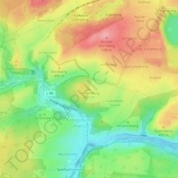
Name: Klingenberg topographic map, elevation, terrain.
Average elevation: 479 m
Minimum elevation: 421 m
Maximum elevation: 539 m
Other topographic maps
Click on a map to view its topography, its elevation and its terrain.
Königshütte
Deutschland > Sachsen-Anhalt > Oberharz am Brocken
Königshütte, Oberharz am Brocken, Landkreis Harz, Sachsen-Anhalt, Deutschland
Average elevation: 484 m
Bielstein
Deutschland > Sachsen-Anhalt > Oberharz am Brocken
Bielstein, Oberharz am Brocken, Landkreis Harz, Sachsen-Anhalt, Deutschland
Average elevation: 460 m
Rotestein
Deutschland > Sachsen-Anhalt > Oberharz am Brocken
Rotestein, Oberharz am Brocken, Landkreis Harz, Sachsen-Anhalt, 38889, Deutschland
Average elevation: 449 m