Bucks County topographic map
Interactive map
Click on the map to display elevation.
About this map
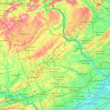
Name: Bucks County topographic map, elevation, terrain.
Location: Bucks County, Pennsylvania, United States (40.04980 -75.48393 40.60872 -74.72107)
Average elevation: 98 m
Minimum elevation: -2 m
Maximum elevation: 312 m
According to the Trewartha climate classification system, the Piedmont (United States) section of Bucks County, which is located roughly northwest of U.S. Route 1, has a Temperate Continental Climate with hot and slightly humid summers, cold winters and year-around precipitation (Dcao). Dcao climates are characterized by at least one month having an average mean temperature ≤ 32.0 °F (0 °C), four to seven months with an average mean temperature ≥ 50.0 °F (10 °C), at least one month with an average mean temperature ≥ 72.0 °F (22 °C) and no significant precipitation difference between seasons. According to the Köppen climate classification system, the climate is a hot-summer, wet all year, humid continental climate (Dfa). During the summer months in the Piedmont, episodes of extreme heat and humidity can occur with heat index values > 102 °F (39 °C). The average wettest month is July which corresponds with the annual peak in thunderstorm activity. During the winter months, episodes of extreme cold and wind can occur with wind chill values < −16 °F (−27 °C). The plant hardiness zone at Haycock Mountain, elevation 968 ft (295 m), is 6b with an average annual extreme minimum air temperature of −4.6 °F (−20 °C). The average seasonal (Nov-Apr) snowfall total is between 26 and 36 inches (66 and 91 cm) depending on elevation and distance from the Atlantic Ocean. The average snowiest month is February which correlates with the annual peak in nor'easter activity. Some areas of the Piedmont farther south and along the river below New Hope are in hardiness zone 7a, as is the Atlantic Coastal Plain region of Bucks.
Other topographic maps
Click on a map to view its topography, its elevation and its terrain.
Gladwyne
United States > Pennsylvania > Montgomery County > Lower Merion Township
Gladwyne, Lower Merion Township, Montgomery County, Pennsylvania, 19035, United States
Average elevation: 92 m
DuBois
United States > Pennsylvania > Clearfield County
DuBois, Clearfield County, Pennsylvania, 15801, United States
Average elevation: 450 m
Wilkes-Barre
United States > Pennsylvania > Luzerne County
Wilkes-Barre, Luzerne County, Pennsylvania, United States
Average elevation: 218 m
Benner Township
United States > Pennsylvania > Centre County
Benner Township, Centre County, Pennsylvania, United States
Average elevation: 347 m
Philadelphia
Philadelphia, Pennsylvania, 19140, United States
Average elevation: 68 m
Lancaster County
Lancaster County, Pennsylvania, United States
Average elevation: 158 m
Apollo
United States > Pennsylvania > Armstrong County
Apollo, Armstrong County, Pennsylvania, United States
Average elevation: 300 m
Stanwood
United States > Pennsylvania > Bucks County > Bensalem Township
Stanwood, Bensalem Township, Bucks County, Pennsylvania, 19020, United States
Average elevation: 31 m
Water Street
United States > Pennsylvania > Huntingdon County > Morris Township
Water Street, Morris Township, Huntingdon County, Pennsylvania, 16683, United States
Average elevation: 319 m
Liberty
United States > Pennsylvania > Allegheny County
Liberty, Allegheny County, Pennsylvania, United States
Average elevation: 283 m
Youngwood
United States > Pennsylvania > Westmoreland County
Youngwood, Westmoreland County, Pennsylvania, 15697, United States
Average elevation: 319 m
Five Points
United States > Pennsylvania > Westmoreland County > Salem Township > Five Points
Five Points, Salem Township, Westmoreland County, Pennsylvania, 15633, United States
Average elevation: 385 m
Hamilton Township
United States > Pennsylvania > Franklin County > Hamilton Township
Hamilton Township, Franklin County, Pennsylvania, United States
Average elevation: 213 m
Lancaster
United States > Pennsylvania > Lancaster County > Lancaster
Lancaster, Lancaster County, Pennsylvania, United States
Average elevation: 102 m
Philadelphia
United States > Pennsylvania > Philadelphia County > Philadelphia
Philadelphia, Philadelphia County, Pennsylvania, 19110, United States
Average elevation: 35 m
Coverdale
United States > Pennsylvania > Allegheny County > Bethel Park > Coverdale
Coverdale, Bethel Park, Allegheny County, Pennsylvania, 15102, United States
Average elevation: 354 m
Girard Township
United States > Pennsylvania > Girard Township
Girard Township, Clearfield County, Pennsylvania, 16850, United States
Average elevation: 521 m
Hempfield Township
United States > Pennsylvania > Westmoreland County
Hempfield Township, Westmoreland County, Pennsylvania, United States
Average elevation: 340 m
Carbon County
Carbon County, Pennsylvania, United States
Average elevation: 387 m
Butler County
Butler County, Pennsylvania, United States
Average elevation: 376 m
Franklin County
Franklin County, Pennsylvania, United States
Average elevation: 303 m
Beaver County
Beaver County, Pennsylvania, United States
Average elevation: 325 m
Springfield Township
United States > Pennsylvania > York County > Springfield Township
Springfield Township, York County, Pennsylvania, 17360, United States
Average elevation: 225 m
Lehigh County
Lehigh County, Pennsylvania, United States
Average elevation: 186 m
Greenwich Township
United States > Pennsylvania > Berks County
Greenwich Township, Berks County, Pennsylvania, 19534, United States
Average elevation: 173 m