
Saratoga County topographic map
Interactive map
Click on the map to display elevation.
Saratoga County
Saratoga County is situated in the eastern portion of New York State, north of Albany, northwest of Troy, and east of Utica. According to the U.S. Census Bureau, the county has a total area of 844 square miles (2,190 km2), of which 810 square miles (2,100 km2) is land and 34 square miles (88 km2) (4.0%) is water. The Hudson River forms the eastern border of the county, while the Mohawk River demarcates its southern border. The highest elevation in Saratoga County is at the peak of Hadley Mountain in the Adirondack Mountains, at 2,675 feet (815 meters), while the lowest elevation is 69 feet (21 meters), at the waterfront of the Village of Waterford, at the confluence of the Mohawk and Hudson rivers.
About this map
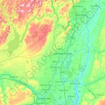
Name: Saratoga County topographic map, elevation, terrain.
Location: Saratoga County, New York, United States (42.77546 -74.16010 43.39797 -73.57327)
Average elevation: 218 m
Minimum elevation: 3 m
Maximum elevation: 833 m
Other topographic maps
Click on a map to view its topography, its elevation and its terrain.
Central Park
United States > New York > New York County > New York
In June 1856, Fernando Wood appointed a "consulting board" of seven people, headed by author Washington Irving, to inspire public confidence in the proposed development. Wood hired military engineer Egbert Ludovicus Viele as the park's chief engineer, tasking him with a topographical survey of the site. The…
Average elevation: 26 m
Sonyea State Forest
United States > New York > Livingston County > Town of Mount Morris
Average elevation: 231 m
Quarry Heights
United States > New York > Westchester County > Town/Village of Harrison
Average elevation: 112 m
Colonial Heights
United States > New York > Dutchess County > MacDonnell Heights
Average elevation: 77 m
West Mount Vernon
United States > New York > Westchester County > Mount Vernon > West Mount Vernon
Average elevation: 49 m