
Curchorem topographic map
Interactive map
Click on the map to display elevation.
Curchorem
Curchorem is located at 15°15′37″N 74°06′30″E / 15.26028°N 74.10833°E / 15.26028; 74.10833 and has an average elevation of 13 metres (43 ft). The confluence of Uguem and Guleli rivers at Sanguem or Sangam is known as Zuari river. It runs north west up to sanvordem. Further it runs up to the west till Kushawati River and joins at Xelvona. Then again it changes its direction to the north till it reaches Panchwadi and further flows up to Rachol. again flows up to north to Borim and further north-west up to Racaim, Durbhat and finally to the Arabian Sea where it joins to Mormugao. It covers 67 kilometers in the goa district.
About this map
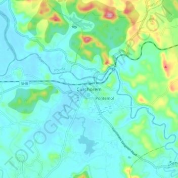
Name: Curchorem topographic map, elevation, terrain.
Location: Curchorem, Quepem, South Goa, Goa, 403706, India (15.22174 74.06828 15.30174 74.14828)
Average elevation: 35 m
Minimum elevation: 0 m
Maximum elevation: 177 m