
Lunglei topographic map
Interactive map
Click on the map to display elevation.
About this map
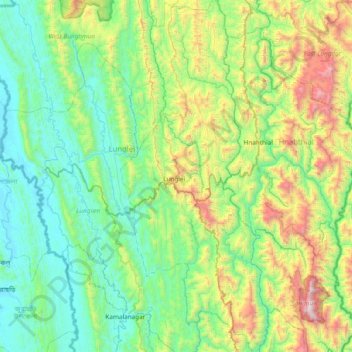
Name: Lunglei topographic map, elevation, terrain.
Location: Lunglei, Mizoram, India (22.54807 92.63088 23.24675 92.94974)
Average elevation: 510 m
Minimum elevation: 27 m
Maximum elevation: 2,130 m
Other topographic maps
Click on a map to view its topography, its elevation and its terrain.
Aizawl
Aizawl has a mild, sub-tropical climate due to its location and elevation. Under the Köppen climate classification, Aizawl features a humid subtropical climate (Cwa). In summer, temperatures are moderately warm, averaging around 20–30 °C (68–86 °F). In winter, daytime temperatures are cooler in…
Average elevation: 562 m