
Paithan topographic map
Interactive map
Click on the map to display elevation.
About this map
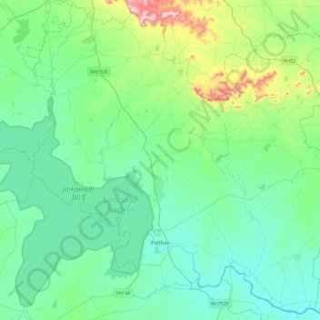
Name: Paithan topographic map, elevation, terrain.
Location: Paithan, Aurangabad, Maharashtra, India (19.37796 75.20193 19.78988 75.65653)
Average elevation: 493 m
Minimum elevation: 424 m
Maximum elevation: 789 m
Paithan is located at 19°29′N 75°23′E / 19.48°N 75.38°E / 19.48; 75.38. It has an average elevation of 458 m (1,503 ft).
Other topographic maps
Click on a map to view its topography, its elevation and its terrain.
Kham Jalgon
India > Maharashtra > Paithan
Kham Jalgon, Paithan, Aurangabad District, Maharashtra, India
Average elevation: 478 m
Jayakwadi Dam
India > Maharashtra > Paithan
Jayakwadi Dam, Paithan, Aurangabad, Maharashtra, 431107, India
Average elevation: 456 m