
Börgerende topographic map
Interactive map
Click on the map to display elevation.
About this map
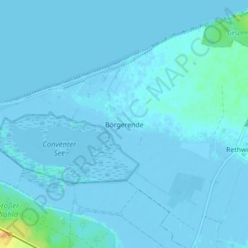
Name: Börgerende topographic map, elevation, terrain.
Average elevation: 1 m
Minimum elevation: -6 m
Maximum elevation: 31 m
Other topographic maps
Click on a map to view its topography, its elevation and its terrain.
Börgerende-Rethwisch
Deutschland > Mecklenburg-Vorpommern > Landkreis Rostock > Börgerende-Rethwisch
Börgerende-Rethwisch, Bad Doberan-Land, Landkreis Rostock, Mecklenburg-Vorpommern, 18211, Deutschland
Average elevation: 3 m