Geolocate

Gurgaon topographic map

Interactive map

Click on the map to display elevation.

About this map

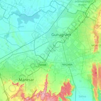
Name: Gurgaon topographic map, elevation, terrain.

Location: Gurgaon, Gurugram District, Haryana, India (28.31539 76.86563 28.54090 77.12654)

Average elevation: 237 m

Minimum elevation: 210 m

Maximum elevation: 340 m

Other topographic maps

Click on a map to view its topography, its elevation and its terrain.

Sector 62

India > Haryana > Gurugram District

Sector 62, Gurgaon, Gurugram District, Haryana, India

Average elevation: 235 m

Sector 85

India > Haryana > Gurugram District

Sector 85, Manesar, Gurugram District, Haryana, India

Average elevation: 228 m

Sector 109

India > Haryana > Gurugram District

Sector 109, Gurgaon, Gurugram District, Haryana, India

Average elevation: 214 m

Leisure Valley Park

India > Haryana > Gurugram District

Leisure Valley Park, Sector 29, Gurgaon, Gurugram District, Haryana, India

Average elevation: 235 m

Sohna

India > Haryana > Gurugram District

Sohna, Gurugram, Haryana, India

Average elevation: 242 m