
Baraut topographic map
Interactive map
Click on the map to display elevation.
About this map
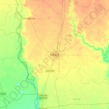
Name: Baraut topographic map, elevation, terrain.
Location: Baraut, Baghpat, Uttar Pradesh, 250611, India (28.94279 77.09875 29.26279 77.41875)
Average elevation: 227 m
Minimum elevation: 210 m
Maximum elevation: 239 m
Baraut is located at 29.6°N 77.16°E, covering an area of 10.36 square kilometers (4.00 sq mi) and lying between the Ganga and Yamuna river plains. Its average elevation is 231 m (758 feet). Baraut is served by two state highways, SH-57 and SH-82.