
Southeast Sulawesi topographic map
Interactive map
Click on the map to display elevation.
About this map
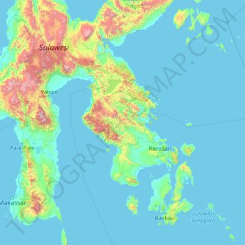
Name: Southeast Sulawesi topographic map, elevation, terrain.
Location: Southeast Sulawesi, Indonesia (-6.10912 119.16796 -0.98912 124.28796)
Average elevation: 236 m
Minimum elevation: -2 m
Maximum elevation: 3,405 m
Other topographic maps
Click on a map to view its topography, its elevation and its terrain.
Muna Island
Indonesia > Southeast Sulawesi > Baubau
Muna Island, Baubau, Southeast Sulawesi, Indonesia
Average elevation: 70 m