
Pavagadh topographic map
Interactive map
Click on the map to display elevation.
Pavagadh
Pavagadh is the gateway to Panchmahal. The locations of hilly areas around Halol provide good scenery. Pavagadh Hill has total height of 822 meters and you can find many scenic trails to climb including waterfalls during monsoon time. The plateau at an altitude of 490 meters is known as Machi Haveli. The bus service has been extended up to Machi.
About this map
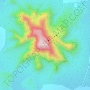
Name: Pavagadh topographic map, elevation, terrain.
Location: Pavagadh, Halol Taluka, Panchmahal, Gujarat, 389360, India (22.44221 73.49683 22.48221 73.53683)
Average elevation: 284 m
Minimum elevation: 131 m
Maximum elevation: 818 m
Other topographic maps
Click on a map to view its topography, its elevation and its terrain.