
Dang topographic map
Interactive map
Click on the map to display elevation.
About this map
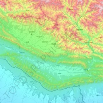
Name: Dang topographic map, elevation, terrain.
Location: Dang, Lumbini Province, Nepal (27.67644 81.92083 28.28303 82.81032)
Average elevation: 746 m
Minimum elevation: 109 m
Maximum elevation: 2,914 m
The Dudhwas rise steeply to a crest at about 700 meters, then slope more gradually into the Deukhuri Valley, down to 250 meters elevation at the Rapti River. The Dudhwas extend more than 100 km, causing the Rapti to detour west around them before turning southeast down the main trend of the plains into India. Deukhuri's climate is nearly tropical and it is well watered by the river, as well as possessing abundant groundwater. North of Deukhuri Valley, the Dang Range rises as high as 1,000 meters with passes at about 700 meters. The Dang Valley lies north of these hills, drained by the Babai River tributary to the Ghaghara (Karnali). Valley elevations range from 600 meters along the Babai with alluvial slopes gradually rising northward to 700 meters along the base of the Mahabharat Range. The district then extends upslope to the crest of the Mahabharats at 1,500 to 1,700 meters elevation. The bordering districts to the north are Pyuthan, Rolpa, and Salyan. The Rapti River of Western Nepal traverses through most of the lower Dang valley. It flows beneath the Churia range first on the northern side of the hills and then leaves the hills on the southern side. Nepal's second-longest bridge over Rapti river in Dang district connects Sisahaniya of Rapti Rural Municipality with Mahadeva of Gadawa Rural Municipality in the district.
Other topographic maps
Click on a map to view its topography, its elevation and its terrain.
Simjung
Nepal > Gandaki Province > Gorkha
Simjung, Ajirkot, Gorkha, Gandaki Province, Nepal
Average elevation: 1,619 m
Sauraha Chok
Nepal > Bagmati Province > Chitwan > Ratnanagar
Sauraha Chok, Ratnanagar-01, Ratnanagar, Chitwan, Bagmati Province, 44204, Nepal
Average elevation: 197 m
Mount Everest
Nepal > Koshi Province > Solukhumbu
Mount Everest, Khumbupasanglahmu, Solukhumbu, Koshi Province, Nepal
Average elevation: 7,847 m
Premnagar
Nepal > Madhesh Province > Mahottari
Premnagar, Bardibas, Mahottari, Madhesh Province, Nepal
Average elevation: 141 m
Dambiodar village
Nepal > Bagmati Province > Nuwakot
Dambiodar village, Ducheshwar-01, Ducheshwar, Nuwakot, Bagmati Province, Nepal
Average elevation: 1,777 m
Parbati Kunda
Nepal > Bagmati Province > Rasuwa
Parbati Kunda, Rasuwa, Bagmati Province, Nepal
Average elevation: 3,310 m
Khopi
Nepal > Koshi Province > Taplejung
Khopi, Sidingba-07, Sidingba, Taplejung, Koshi Province, Nepal
Average elevation: 1,852 m
Bharatpur
Nepal > Bagmati Province > Chitwan
Bharatpur, Chitwan, Bagmati Province, Nepal
Average elevation: 381 m
Phaplu
Nepal > Koshi Province > Solukhumbu
Phaplu, Solududhkunda, Solukhumbu, Koshi Province, 50600, Nepal
Average elevation: 2,518 m
Dhanpalthan
Nepal > Koshi Province > Morang
Dhanpalthan, Morang, Koshi Province, Nepal
Average elevation: 71 m
Simi Gaun
Nepal > Bagmati Province > Dolakha
Simi Gaun, Gaurishankar, Dolakha, Bagmati Province, Nepal
Average elevation: 2,103 m
Malibara
Nepal > Madhesh Province > Mahottari
Malibara, Jaleswar, Mahottari, Madhesh Province, 45700, Nepal
Average elevation: 63 m
Achham
Nepal > Sudurpashchim Province
Achham, Sudurpashchim Province, 10709, Nepal
Average elevation: 1,387 m
Tumling
Nepal > Koshi Province > Ilam
Tumling, 03DR020, Sandakpur-05, Sandakpur, Ilam, Koshi Province, Nepal
Average elevation: 2,759 m
Tingla
Nepal > Koshi Province > Solukhumbu
Tingla, Nechasalyan-06, Nechasalyan, Solukhumbu, Koshi Province, Nepal
Average elevation: 1,843 m
Pokhra
Nepal > Karnali Province > Dailekh
Pokhra, Gurans-02, Gurans, Dailekh, Karnali Province, Nepal
Average elevation: 1,106 m
Pathari
Nepal > Koshi Province > Morang
Pathari, Patahrishanishchare, Morang, Koshi Province, 56600, Nepal
Average elevation: 139 m
Annapurna
Nepal > Gandaki Province > Kaski
Annapurna, Kaski, Gandaki Province, 33711, Nepal
Average elevation: 2,974 m
Chautari
Nepal > Gandaki Province > Kaski > Baskharka
Chautari, Annapurna-04, Baskharka, Annapurna, Kaski, Gandaki Province, Nepal
Average elevation: 1,521 m
Pipalla Bazar
Pipalla Bazar, Dipayal Silgadi-04, Dipayal, Dipayal Silgadi, Doti, Nepal
Average elevation: 614 m
Muktinath
Nepal > Gandaki Province > Mustang > Ranipauwa
Muktinath, Barhagaun Muktikhsetra-01, Ranipauwa, Barhagaun Muktikhsetra, Mustang, Gandaki Province, 33100, Nepal
Average elevation: 3,965 m
Kanchanpur
Kanchanpur, Ramgopalpur, Mahottari, Madhesh Province, Nepal
Average elevation: 90 m
Lalitpur
Nepal > Bagmati Province > Lalitpur
Lalitpur, Lalitpur Metropolitan City, Lalitpur, Bagmati Province, 44707, Nepal
Average elevation: 1,316 m
Nawalpur
Nawalpur, Indrawati, Sindhupalchowk, Bagmati Pradesh, Nepal
Average elevation: 1,463 m
Thakuri Thana
Thakuri Thana, Rannada, Kotdewal, Masta, Bajhang, Sudurpashchim Pradesh, Nepal
Average elevation: 1,958 m
Rapla
Nepal > Darchula District (Nepal)
Rapla, Byash Municipality, Darchula District (Nepal), Sudurpashchim Pradesh, Nepal
Average elevation: 3,607 m
Musikot
Nepal > Western Rukum District
Musikot, Western Rukum District, Karnali Pradesh, 22000, Nepal
Average elevation: 1,594 m
Lalitpur
Nepal > Central Development Region
Lalitpur, Bagmati, Central Development Region, Nepal
Average elevation: 1,536 m
Musikot
Nepal > Western Rukum District
Musikot, Western Rukum District, Karnali Pradesh, 22000, Nepal
Average elevation: 1,742 m
Chaurjahari
Nepal > Western Rukum District
Chaurjahari, Western Rukum District, Karnali Pradesh, Nepal
Average elevation: 1,141 m